|
|
| Mesoscale Discussion 607 | |
| Next MD > | |
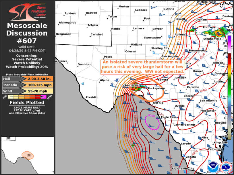 | |
   Mesoscale Discussion 0607
   NWS Storm Prediction Center Norman OK
   0644 PM CDT Tue Apr 28 2026

   Areas affected...Southwest Texas

   Concerning...Severe potential...Watch unlikely

   Valid 282344Z - 290145Z

   Probability of Watch Issuance...20 percent

   SUMMARY...An isolated severe thunderstorm will pose a risk of large
   hail for a couple of hours over parts of southwest Texas.  A watch
   is not anticipated.

   DISCUSSION...An isolated intense thunderstorm has formed in Terrell
   county TX, just east of Sanderson.  This cell formed along the
   surface dryline in a very hot/moist and unstable air mass.  This
   storm will likely persist for a couple of hours, tracking into Val
   Verde county.  Left-splits from this cell could affect southern
   Crockett county as well.  Very steep mid-level lapse rates, high
   CAPE, and supercell structures will continue to pose a risk of large
   hail over 2 inches and locally damaging wind gusts.  Coverage of
   storms is expected to remain sparse, so a watch is not currently
   anticipated.

   ..Hart/Mosier.. 04/28/2026

   ...Please see www.spc.noaa.gov for graphic product...

   ATTN...WFO...EWX...SJT...MAF...

   LAT...LON   30370191 30600122 30170043 29790035 29610064 29530113
               29890192 30140208 30370191

   MOST PROBABLE PEAK TORNADO INTENSITY...100-125 MPH
   MOST PROBABLE PEAK WIND GUST...55-70 MPH
   MOST PROBABLE PEAK HAIL SIZE...2.00-3.50 IN
| |
| Top/All Mesoscale Discussions/Forecast Products/Home | |