|
|
| Mesoscale Discussion 583 | |
| Next MD > | |
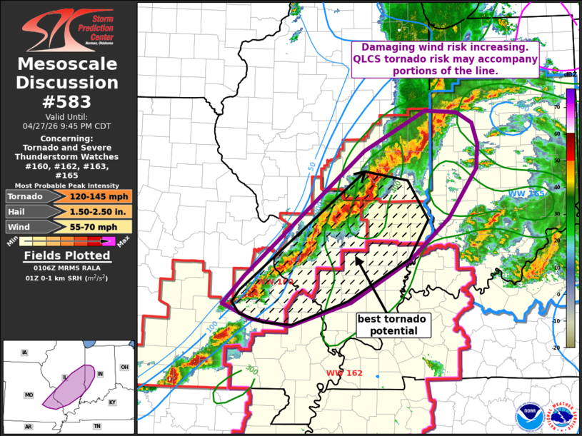 | |
   Mesoscale Discussion 0583
   NWS Storm Prediction Center Norman OK
   0808 PM CDT Mon Apr 27 2026

   Areas affected...west-central IN...central/southern
   IL...east-central MO

   Concerning...Tornado and Severe Thunderstorm Watches
   160...162...163...165...

   Valid 280108Z - 280245Z

   The severe weather threat for Tornado and Severe Thunderstorm
   Watches 160, 162, 163, 165 continues.

   SUMMARY...Damaging wind threat increasing as a organized QLCS
   advances eastward through the evening. Some QLCS tornado risk may
   continue across parts of central/southern IL into east-central MO.

   DISCUSSION...A well-developed QLCS extending from west-central IN
   through central IL into east-central MO will continue eastward
   through the evening. As this line has become better organized as it
   moves into an axis of moderate to strong instability overlapping a
   40+ kt low level jet, swaths of damaging winds will be possible.
   Additionally, low-level shear remains favorable (0-1 km SRH greater
   than 300 m2/s2) for tornadoes and a few QLCS mesovortex tornadoes
   will also be possible. New watch issuance or local extension of
   existing tornado watches will likely be needed soon.

   ..Leitman.. 04/28/2026

   ...Please see www.spc.noaa.gov for graphic product...

   ATTN...WFO...IND...PAH...ILX...LSX...SGF...

   LAT...LON   39898874 40458762 40438704 40288675 39978665 39638668
               38938720 38338789 37728897 37389007 37499079 37709128
               38109089 39898874

   MOST PROBABLE PEAK TORNADO INTENSITY...120-145 MPH
   MOST PROBABLE PEAK WIND GUST...55-70 MPH
   MOST PROBABLE PEAK HAIL SIZE...1.50-2.50 IN
| |
| Top/All Mesoscale Discussions/Forecast Products/Home | |