|
|
| Mesoscale Discussion 566 | |
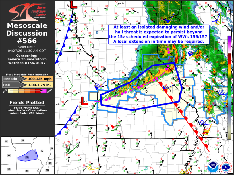 | |
Mesoscale Discussion 0566 NWS Storm Prediction Center Norman OK 0941 AM CDT Mon Apr 27 2026 Areas affected...Central Missouri Concerning...Severe Thunderstorm Watch 156...157... Valid 271441Z - 271630Z CORRECTED FOR PEAK INTENSITY The severe weather threat for Severe Thunderstorm Watch 156, 157 continues. SUMMARY...The potential for isolated damaging winds and large hail is expected to continue beyond the scheduled 15z expiration of Severe Thunderstorm Watches 156 and 157. A local extension in time may be required. DISCUSSION...As of 14z, mosaic radar imagery indicated a leading bow echo over west-central IL with trailing, outflow-dominant convection bisecting I-70 across central MO. The 12z Springfield, MO sounding indicated a very moist low-level air mass with a pronounced capping inversion at the base of an elevated-mixed layer characterized by 700-500-mb lapse rates of 8.5 C/km. Latest short-term model guidance suggests that the ongoing, trailing convection across central MO will linger beyond the scheduled 15z expiration of WWs 156 and 157. However, currently it appears that the cold pool circulation is not sufficiently strong to overcome the currently capping in place. Furthermore, the largely parallel orientation of the line to the mid/upper-level flow will limit the damaging wind potential. Nonetheless, the presence of strong low-level and deep-layer shear will maintain at least an isolated damaging wind and/or hail threat this morning. ..Mead.. 04/27/2026 ...Please see www.spc.noaa.gov for graphic product... ATTN...WFO...LSX...SGF...EAX... LAT...LON 37869439 38269444 38809293 39489177 39599062 38559023 38009041 37669279 37869439 MOST PROBABLE PEAK TORNADO INTENSITY...100-125 MPH MOST PROBABLE PEAK WIND GUST...55-70 MPH MOST PROBABLE PEAK HAIL SIZE...1.00-1.75 IN | |
| Top/All Mesoscale Discussions/Forecast Products/Home | |