|
|
| Mesoscale Discussion 565 | |
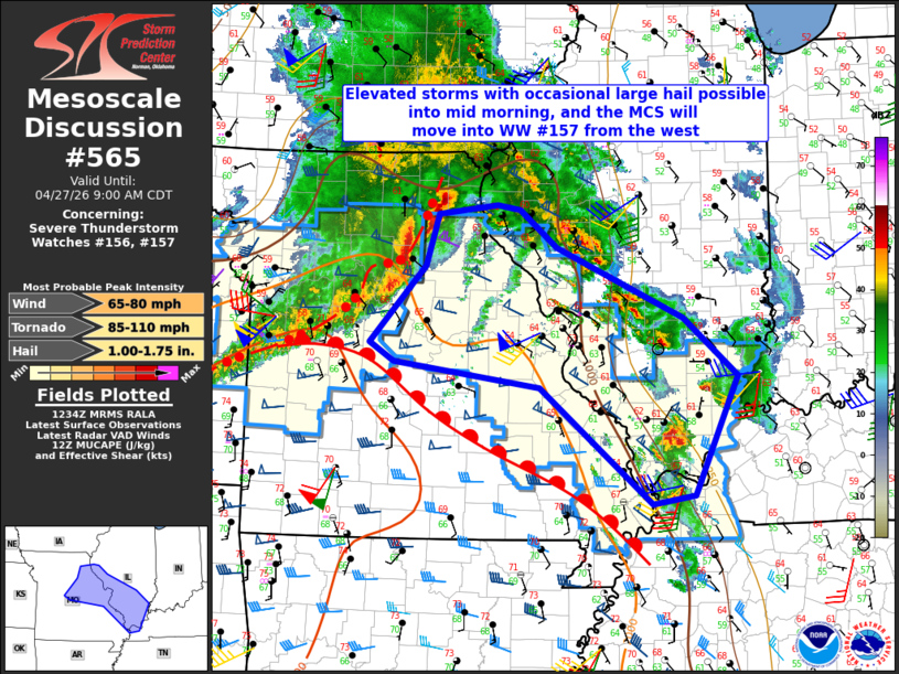 | |
Mesoscale Discussion 0565 NWS Storm Prediction Center Norman OK 0736 AM CDT Mon Apr 27 2026 Areas affected...Eastern/northern Missouri and southern Illinois Concerning...Severe Thunderstorm Watch 156...157... Valid 271236Z - 271400Z The severe weather threat for Severe Thunderstorm Watch 156, 157 continues. SUMMARY...Elevated storms will persist through mid morning into west central and southern Illinois with the threat for large hail. A separate MCS will spread eastward from WW #156 into WW #157. DISCUSSION...Elevated storms continue in a zone of low-level warm advection on the nose of a 50 kt low-level jet. This area has been near the east edge of the destabilization aloft overnight, and this trend should continue with storms into western and southern IL, where large hail of 1-1.75 inches in diameter will be the main threat. Farther west, earlier supercells in KS/MO have evolved into multiple line segments with occasional mesovortices. The strongest portions of the line have been more north-south oriented, orthogonal to the deep-layer shear vectors and with substantial streamwise vorticity in the low levels. Embedded circulations will continue to be possible, though the storms may slightly out pace northward expansion of the surface warm sector and associated surface-based buoyancy. An isolated mesovortex tornado could occur, but the primary threats will remain damaging winds and large hail in the near term. ..Thompson.. 04/27/2026 ...Please see www.spc.noaa.gov for graphic product... ATTN...WFO...PAH...ILX...LSX...SGF...EAX... LAT...LON 38119068 38389265 38589297 39399222 39959206 40059126 40009095 39609044 38848874 38238800 36958860 36868917 38119068 MOST PROBABLE PEAK TORNADO INTENSITY...85-110 MPH MOST PROBABLE PEAK WIND GUST...65-80 MPH MOST PROBABLE PEAK HAIL SIZE...1.00-1.75 IN | |
| Top/All Mesoscale Discussions/Forecast Products/Home | |