|
|
| Mesoscale Discussion 955 | |
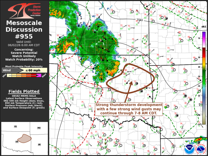 | |
   Mesoscale Discussion 0955
   NWS Storm Prediction Center Norman OK
   0400 AM CDT Tue Jun 02 2026

   Areas affected...parts of northeastern and east central Oklahoma

   Concerning...Severe potential...Watch unlikely

   Valid 020900Z - 021100Z

   Probability of Watch Issuance...20 percent

   SUMMARY...A lingering cluster of strong thunderstorms may persist
   into 7-8 AM CDT time frame, accompanied by occasional strong gusts
   while overspreading the I-44 and i-40 corridors of eastern Oklahoma.

   DISCUSSION...Though trailing the leading edge of the
   east-southeastward advancing convective outflow, vigorous convective
   development is being maintained, and still contributing to 2-4 mb
   2-hourly surface pressure rises within the deeper surface cold pool.
   This has becoming increasingly displaced to the southeast of the
   mesoscale convective vortex, now east of Medicine Lodge KS, aided by
   veering of stronger rear inflow to a northwesterly component.

   It is possible that forcing associated with the cold pool may
   maintain sufficient strength to support ongoing convection at
   current intensities into the 12-13Z time, aided by continuing inflow
   of air emanating from a seasonably moist boundary-layer
   (characterized by large potential instability) across the Interstate
   44 into 40 corridors of eastern Oklahoma.

   ..Kerr.. 06/02/2026

   ...Please see www.spc.noaa.gov for graphic product...

   ATTN...WFO...TSA...OUN...

   LAT...LON   36589583 36019442 35579466 35199592 35509697 35759704
               36109627 36589583

   MOST PROBABLE PEAK WIND GUST...UP TO 60 MPH
| |
| Top/All Mesoscale Discussions/Forecast Products/Home | |