|
|
| Mesoscale Discussion 954 | |
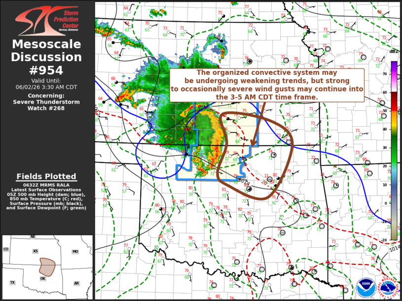 | |
Mesoscale Discussion 0954 NWS Storm Prediction Center Norman OK 0133 AM CDT Tue Jun 02 2026 Areas affected...parts of south central/southeastern Kansas and north central/northeastern Oklahoma Concerning...Severe Thunderstorm Watch 268... Valid 020633Z - 020830Z The severe weather threat for Severe Thunderstorm Watch 268 continues. SUMMARY...At its current motion, the ongoing convective system will progress east-southeast of the watch within the hour. It remains unclear how long this cluster will be maintained through the overnight hours, but it is possible that potential for gusts exceeding severe limits may be diminishing enough that a new severe weather watch may not be needed. DISCUSSION...Vigorous thunderstorm development persists on the leading edge of the organized convective system, which has recently been propagating east-southeastward at 30-35 kt. Westerly/northwesterly rear inflow to the south of an associated mesoscale convective vortex now progressing to the north of Medicine Lodge remains on the order of 40-50+ kt, and a corridor of 2-4+ mb (up to 6.5 mb in the 06Z Medicine Lodge observation) 2-hourly surface pressure rises remain evident on the leading edge of the cold pool. However, there have been signs of weakening trends in latest radar data, and the latest Rapid Refresh/HRRR suggest more substantive weakening trends during the next few hours, as inhibition for inflow parcels emanating from the seasonably moist boundary layer continues to slowly increase. ..Kerr.. 06/02/2026 ...Please see www.spc.noaa.gov for graphic product... ATTN...WFO...TSA...ICT...OUN... LAT...LON 37779757 37609611 37019545 35739620 36049742 36349771 37049744 37779757 | |
| Top/All Mesoscale Discussions/Forecast Products/Home | |