|
|
| Mesoscale Discussion 934 | |
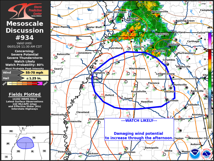 | |
   Mesoscale Discussion 0934
   NWS Storm Prediction Center Norman OK
   0930 AM CDT Mon Jun 01 2026

   Areas affected...western/middle Tennessee...northern
   Mississippi...northern Alabama

   Concerning...Severe potential...Severe Thunderstorm Watch likely

   Valid 011430Z - 011630Z

   Probability of Watch Issuance...80 percent

   SUMMARY...Damaging wind risk to increase through the late
   morning/early afternoon.

   DISCUSSION...A cluster of storms continues to move south and east
   into western Tennessee, with occasional taller echo tops and
   lightning activity steadily increasing over the last hour. To the
   south, a hot and very unstable air mass is in place with
   temperatures in the low to mid 80s across southern TN into northern
   MS. Though flow is generally weak, forecast soundings indicate
   steepening low-level lapse rates are expected across much of the
   region. As the storms continue into the better air mass to the
   south, will support potential for increasing damaging wind threat
   downstream through the afternoon. A watch will likely be needed
   soon.

   ..Thornton/Mosier.. 06/01/2026

   ...Please see www.spc.noaa.gov for graphic product...

   ATTN...WFO...OHX...BMX...HUN...MEG...

   LAT...LON   34528993 34829004 35039006 35249000 35708931 35968857
               35938775 35738725 35438687 34698651 34318651 34038708
               33958809 33958873 33998908 34208957 34528993

   MOST PROBABLE PEAK WIND GUST...55-70 MPH
   MOST PROBABLE PEAK HAIL SIZE...UP TO 1.25 IN
| |
| Top/All Mesoscale Discussions/Forecast Products/Home | |