|
|
| Mesoscale Discussion 922 | |
| Next MD > | |
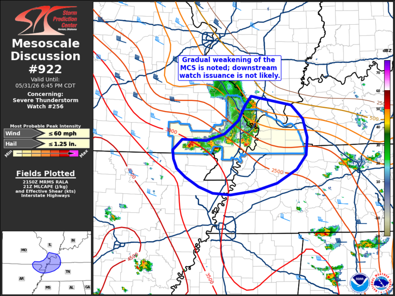 | |
Mesoscale Discussion 0922 NWS Storm Prediction Center Norman OK 0452 PM CDT Sun May 31 2026 Areas affected...Portions of the Mid-Mississippi River Valley Concerning...Severe Thunderstorm Watch 256... Valid 312152Z - 312345Z The severe weather threat for Severe Thunderstorm Watch 256 continues. SUMMARY...A gradual weakening trend is noted with the MCS moving across the lower OH/mid-MS Valley region. While some severe threat may persist for the next 1-2 hours, downstream watch issuance will likely not be needed. DISCUSSION...GOES IR imagery over the past two hours reveals steadily warming cloud-top temperatures of the MCS moving across far southeast MO. Concurrently, MRMS VIL imagery shows the line beginning to segment into more isolated cells, and an outflow boundary has recently become apparent ahead of the line in KPAH reflectivity data. These signs all point towards a steady weakening of the MCS, which is expected to continue as it moves southeastward where deep-layer wind shear becomes increasingly weak. Moderate buoyancy remains immediately downstream of the MCS (MLCAPE values upwards of 3000 J/kg), which will likely continue to support periodic pulses within the line and/or along the outflow boundary. This convection will be capable of sporadic large hail and strong/severe downbursts, but confidence in a prolonged or well-organized severe threat is limited given the marginal deep-layer wind shear. ..Moore.. 05/31/2026 ...Please see www.spc.noaa.gov for graphic product... ATTN...WFO...OHX...PAH...MEG...LZK... LAT...LON 36759088 36739032 36868989 37128958 37408943 37578927 37418833 37148807 36808797 36478799 36198821 35948868 35798917 35728975 35759016 35869049 36049080 36209100 36389109 36559110 36759088 MOST PROBABLE PEAK WIND GUST...UP TO 60 MPH MOST PROBABLE PEAK HAIL SIZE...UP TO 1.25 IN | |
| Top/All Mesoscale Discussions/Forecast Products/Home | |