root@sleepynerdlive.com
:
~
$
su - sleepynerd && cat $HOME/public_html/posts/spc-md-926.txt | parse_content --format=auto
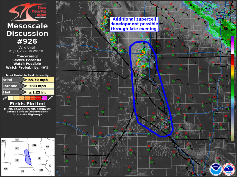
MD 0926 CONCERNING SEVERE POTENTIAL…WATCH POSSIBLE FOR SOUTHEAST SOUTH DAKOTA INTO EASTERN NEBRASKA AND FAR WESTERN IOWA
Mesoscale Discussion 0926
NWS Storm Prediction Center Norman OK
0726 PM CDT Sun May 31 2026

Areas affected...Southeast South Dakota into eastern Nebraska and
far western Iowa

Concerning...Severe potential...Watch possible

Valid 010026Z - 010230Z

Probability of Watch Issuance...40 percent

SUMMARY...Additional severe thunderstorm development is possible
along the I-29 corridor through the late evening hours. Confidence
in storm coverage is limited, but conditions are being monitored for
watch issuance.

DISCUSSION...A supercell with a history of at least one brief
tornado, along with several additional attempts at sustained deep
convection, to the west of the Sioux Falls, SD have been monitored
over the past hour for storm maintenance/longevity after several
earlier failed attempts at robust convection. This supercell has
shown resistance to destructive interference as it shifts east away
from the initiating boundary and into an environment with relatively
weak low-level shear (but 30-35 knots of 0-6 km BWD) based on the
nearby KFSD VWP. Additionally, new cell development south of the
supercell has shown steadily increasing echo tops, suggesting that
these cells may also be sustained and could pose a severe threat in
the coming hours.

Further south, several low-level confluence bands are noted in
surface observations and GOES imagery intersecting the primary
surface trough/dryline. Percolating congestus is also noted at one
intersection near the Omaha, NE area. Based on these trends and some
recent high-res guidance, additional thunderstorm development along
this boundary appears possible through 04 UTC. Storms that develop
along the boundary will likely pose a threat for large hail and
severe gusts given adequate buoyancy and deep-layer shear. Marginal
low-level SRH away from the boundaries will likely modulate any
further tornado threat, but another brief tornado or two could occur
given focused low-level vorticity along the surface boundary
intersections. Watch issuance may be needed if convection becomes
sufficiently widespread in the coming hours.

..Moore/Guyer.. 06/01/2026

...Please see www.spc.noaa.gov for graphic product...

ATTN...WFO...FSD...OAX...GID...

LAT...LON   43169645 41559584 40949571 40789580 40709606 40709631
            41209734 41659750 43659774 43899774 44059752 44099711
            44049687 43849668 43569648 43169645

MOST PROBABLE PEAK TORNADO INTENSITY...UP TO 90 MPH
MOST PROBABLE PEAK WIND GUST...55-70 MPH
MOST PROBABLE PEAK HAIL SIZE...UP TO 1.25 IN