|
|
| Mesoscale Discussion 915 | |
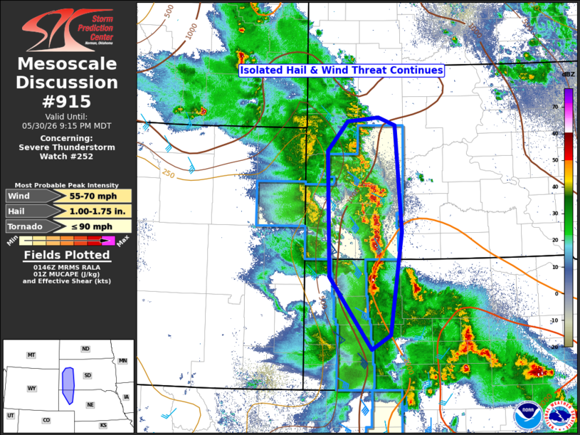 | |
Mesoscale Discussion 0915 NWS Storm Prediction Center Norman OK 0848 PM CDT Sat May 30 2026 Areas affected...parts of northwest Nebraska and western South Dakota Concerning...Severe Thunderstorm Watch 252... Valid 310148Z - 310315Z The severe weather threat for Severe Thunderstorm Watch 252 continues. SUMMARY...A north-south line of thunderstorms continues across portions of Severe Thunderstorm Watch #252. The overall environment remains favorable for isolated large hail and damaging winds in the short term. Trends will be monitored to determine if an extension in time for the watch is needed, but one is currently not expected. DISCUSSION...Thunderstorm intensity continues to wane across most of Severe Thunderstorm Watch #252 this evening. The exception is across portions of far northwest Nebraska and western South Dakota. Here, a slowly westward moving north-south band of thunderstorms has developed/intensified over the last 90 minutes. The environment surrounding these storms remains unstable with MUCAPE around 1000-2000 J/kg, while the deep-layer shear has improved this evening to around 30-35 knots. This will result in a continued threat of large hail and perhaps damaging thunderstorm winds with the strongest cores. Severe Thunderstorm Watch #252 is scheduled to expire at 03Z (9 PM MDT). Trends will be monitored over the next hour to see if a local extension in time is needed, but current expectations are that absent significant increase in intensity, the watch will be allowed to expire on time. ..Marsh.. 05/31/2026 ...Please see www.spc.noaa.gov for graphic product... ATTN...WFO...LBF...UNR...CYS... LAT...LON 41610265 42720354 44640359 45100316 45160251 45030217 43420203 41840226 41610265 MOST PROBABLE PEAK TORNADO INTENSITY...UP TO 90 MPH MOST PROBABLE PEAK WIND GUST...55-70 MPH MOST PROBABLE PEAK HAIL SIZE...1.00-1.75 IN | |
| Top/All Mesoscale Discussions/Forecast Products/Home | |