|
|
| Mesoscale Discussion 718 | |
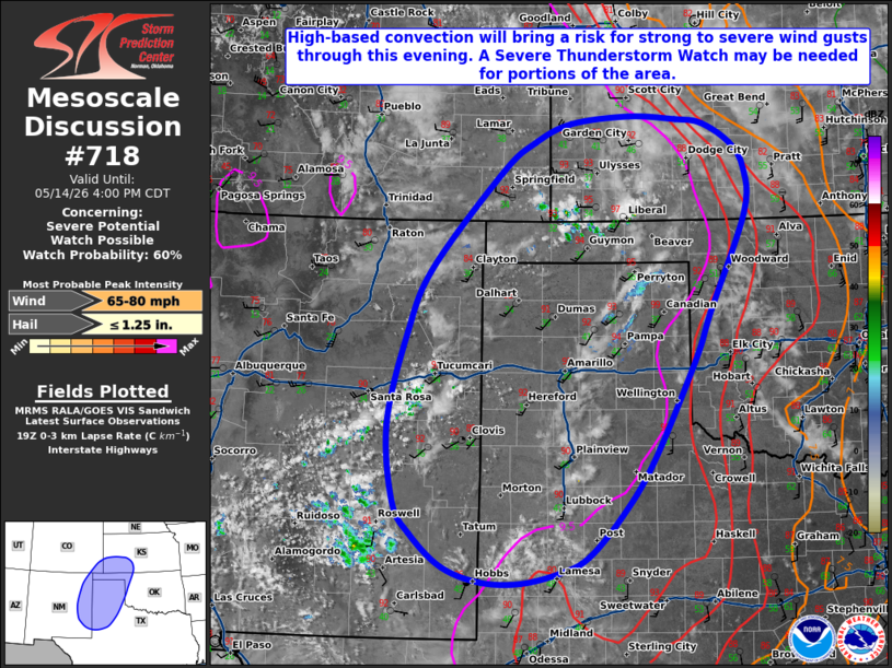 | |
   Mesoscale Discussion 0718
   NWS Storm Prediction Center Norman OK
   0203 PM CDT Thu May 14 2026

   Areas affected...portions of the southern/central High Plains

   Concerning...Severe potential...Watch possible

   Valid 141903Z - 142100Z

   Probability of Watch Issuance...60 percent

   SUMMARY...High-based convection will bring a risk for strong to
   severe wind gusts (some potentially significant) this afternoon and
   evening from portions of West Texas northward into southwest
   Kansas/southeast Colorado.

   DISCUSSION...Moist mid-levels atop deep, well-mixed boundary layer
   profiles and steep low-level lapse rates (as sampled by the 18z DDC
   observed sounding) are contributing to a broad area of deep,
   inverted-v thermodynamic profiles across much of the region, with
   weak buoyancy of 250-500 J/kg MLCAPE (locally higher) expected by
   peak heating. Latest mesoanalysis and a recent ACARS profile from
   AMA indicate remaining inhibition is eroding across the region as
   convective temperatures are approached/breached. Latest
   satellite/radar imagery supports this, with developing high-based
   convection (and a subtle uptick in lightning activity) noted from
   eastern New Mexico into the Oklahoma Panhandle to the west of a
   diffuse dryline.

   Expectation is for convective coverage to increase through the
   afternoon amid continued diurnal heating, especially from the Texas
   Panhandle into southwest Kansas. While only modest mid-level flow is
   noted across the discussion area per regional VWPs, the
   aforementioned deep, dry sub-cloud layers will promote the potential
   for strong to severe wind gusts (and potentially a few significant
   gusts) with convection. Modestly stronger mid-level flow may also
   support the potential for isolated large hail with more robust
   updrafts across the northern portions of the discussion area. Given
   this anticipated severe risk, a Severe Thunderstorm Watch may be
   needed for a portion of the area.

   While high-based convection may pose a similar threat farther south
   into West Texas, convective coverage is currently expected to remain
   more limited with southward extent. Thus, watch issuance appears
   less likely farther south at this time.

   ..Chalmers/Guyer.. 05/14/2026

   ...Please see www.spc.noaa.gov for graphic product...

   ATTN...WFO...OUN...DDC...LUB...AMA...MAF...PUB...ABQ...

   LAT...LON   33620430 34560440 35670411 36420377 37570275 37930228
               38150174 38250087 38210017 38169978 37929936 37619915
               37089916 35899968 35319992 34100055 33460101 32970148
               32800188 32660244 32680302 32850358 33250405 33620430

   MOST PROBABLE PEAK WIND GUST...65-80 MPH
   MOST PROBABLE PEAK HAIL SIZE...UP TO 1.25 IN
| |
| Top/All Mesoscale Discussions/Forecast Products/Home | |