

|
|
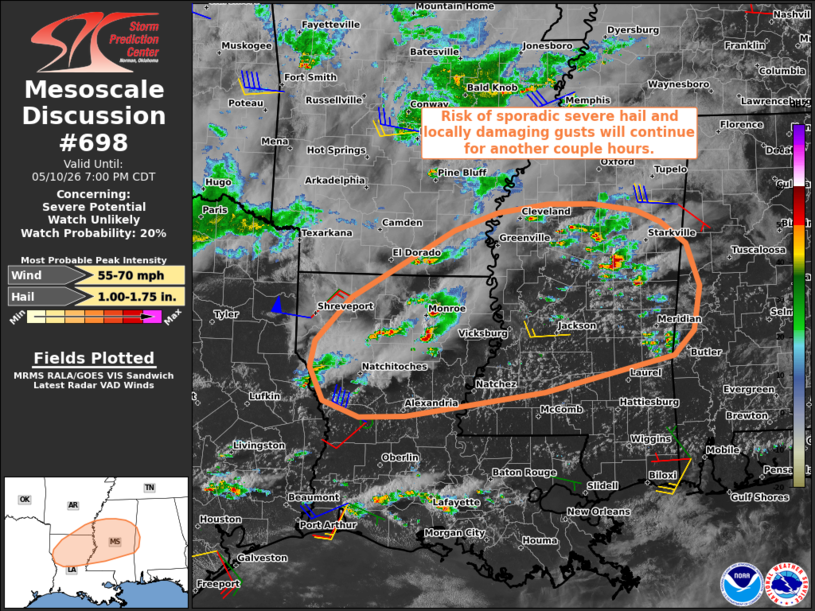
| Mesoscale Discussion 698 | |
 | |
   Mesoscale Discussion 0698
   NWS Storm Prediction Center Norman OK
   0535 PM CDT Sun May 10 2026

   Areas affected...Parts of the lower Mississippi Valley and vicinity

   Concerning...Severe potential...Watch unlikely

   Valid 102235Z - 110000Z

   Probability of Watch Issuance...20 percent

   SUMMARY...Sporadic severe hail and locally damaging wind gusts will
   remain possible with the stronger storms for the next couple hours
   or so.

   DISCUSSION...Widely spaced, loosely organized thunderstorms continue
   to evolve within a zone of broadly confluent low-level flow on the
   far eastern periphery of a remnant outflow boundary extending into
   the lower MS Valley. Earlier diurnal heating of a moist air mass and
   relatively steep midlevel lapse rates (sampled by the 18Z SHV
   sounding) have contributed to a moderately unstable air mass. While
   low-level flow is weak, a belt of enhanced westerly midlevel flow is
   contributing to around 35-40 kt of effective shear. The elongated
   mid/upper-level hodograph and aforementioned buoyancy is supporting
   briefly organized convective cells -- with an attendant risk of
   sporadic severe hail and locally damaging wind gusts. However, given
   a lack of focused forcing for ascent, the severe risk is expected to
   remain transient and brief. Therefore, a watch is not expected,
   though a localized severe risk may persist for another couple hours
   before the boundary layer nocturnally cools/stabilizes.

   ..Weinman/Guyer.. 05/10/2026

   ...Please see www.spc.noaa.gov for graphic product...

   ATTN...WFO...BMX...MOB...MEG...JAN...LZK...LCH...SHV...

   LAT...LON   32159376 32719323 33179244 33589170 33819104 33919028
               33928962 33828896 33688859 33398822 32868802 32308812
               31988842 31549034 31229241 31219308 31409363 31839383
               32159376

   MOST PROBABLE PEAK WIND GUST...55-70 MPH
   MOST PROBABLE PEAK HAIL SIZE...1.00-1.75 IN
| |
| Top/All Mesoscale Discussions/Forecast Products/Home | |