|
|
| Mesoscale Discussion 650 | |
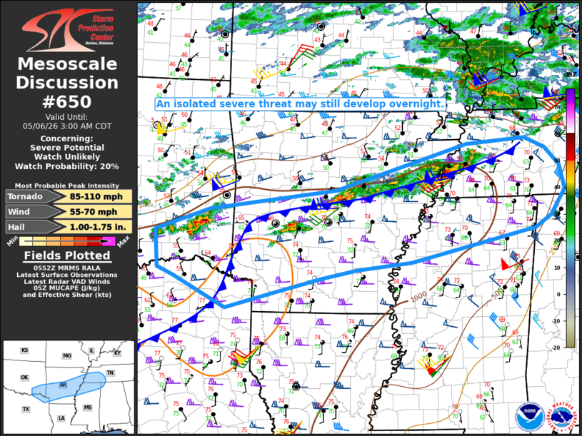 | |
   Mesoscale Discussion 0650
   NWS Storm Prediction Center Norman OK
   1254 AM CDT Wed May 06 2026

   Areas affected...from southeast OK/northeast TX into parts of the
   Mid-South

   Concerning...Severe potential...Watch unlikely

   Valid 060554Z - 060800Z

   Probability of Watch Issuance...20 percent

   SUMMARY...An isolated severe threat may still develop overnight.

   DISCUSSION...Generally weak and disorganized convection is ongoing
   early this morning from parts of southeast OK into AR and western
   TN. Much of this activity is occurring just north of a
   southward-sagging cold front. Low-level warm/moist advection will
   continue to support elevated convection north of the boundary
   overnight, with MUCAPE of 1000-1500 J/kg and strong effective shear
   conditionally supporting organized convection. While storms have
   struggled thus far, it remains possible that an elevated supercell
   or more organized storm cluster could develop with time, posing a
   threat of isolated hail and strong/damaging gusts.

   Storms have also recently developed southwest of Little Rock, to the
   south of the primary front. While this convection may tend to remain
   elevated due to increasing low-level stability, there may be a
   window of opportunity for a near-surface-based storm to evolve
   near/south of the front before convection is undercut. Should this
   occur, a brief tornado threat could evolve, in addition to hail and
   damaging-wind potential.

   ..Dean/Mosier.. 05/06/2026

   ...Please see www.spc.noaa.gov for graphic product...

   ATTN...WFO...OHX...HUN...MEG...JAN...LZK...SHV...TSA...FWD...
   OUN...

   LAT...LON   34399607 34789495 35129230 35928957 36008834 35828792
               35518761 35108751 34658781 34458815 33889073 33749188
               33609261 33379352 33079459 33629569 33749601 34399607

   MOST PROBABLE PEAK TORNADO INTENSITY...85-110 MPH
   MOST PROBABLE PEAK WIND GUST...55-70 MPH
   MOST PROBABLE PEAK HAIL SIZE...1.00-1.75 IN
| |
| Top/All Mesoscale Discussions/Forecast Products/Home | |