|
|
| Mesoscale Discussion 601 | |
| Next MD > | |
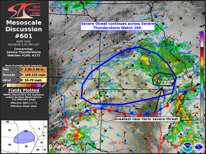 | |
Mesoscale Discussion 0601 NWS Storm Prediction Center Norman OK 0418 PM CDT Tue Apr 28 2026 Areas affected...portions of northeast Oklahoma into southern/central Missouri and northern Arkansas Concerning...Severe Thunderstorm Watch 169...172... Valid 282118Z - 282245Z The severe weather threat for Severe Thunderstorm Watch 169, 172 continues. SUMMARY...Severe potential continues across Severe Thunderstorm Watches 169 and 172, with large hail and occasional damaging/severe wind gusts the primary hazards. DISCUSSION...Ongoing thunderstorms have largely decreased in intensity across much of WW169 over the past hour, with the exception being an elevated supercell ongoing across south-central Missouri that has produced several reports of large hail/damaging wind gusts over the past couple of hours. The greatest severe potential in the near-term is expected with this supercell as it continues eastward into southeastern Missouri. Elsewhere across WW169, low-level warm advection continues to maintain 1000-2000 J/kg MUCAPE with lifted parcel levels between 700-850 mb. Latest high-res guidance continues to depict the potential for additional thunderstorms to develop/move into the western/central portions of the watch over the next 1-2 hours amid continued upper-level support ahead of an approaching shortwave trough moving through Kansas. Elongated hodographs, steep mid-level lapse rates, and effective bulk shear of 60+ kts will continue to support the potential for elevated supercell structures and an attendant risk for large hail and isolated damaging wind gusts with any future development. Any developing thunderstorms that can become surface-based along/south of a surface frontal boundary currently analyzed across northern Arkansas may also bring the potential for a tornado or two. Trends will continue to be monitored, and local watch extensions in time may be needed to cover these threats. ..Chalmers.. 04/28/2026 ...Please see www.spc.noaa.gov for graphic product... ATTN...WFO...PAH...MEG...LSX...LZK...SGF...TSA...ICT... LAT...LON 37289513 37709443 38159361 38399301 38519225 38189116 37729056 37059007 36309032 36089150 35809324 35809499 36099562 36699558 37289513 MOST PROBABLE PEAK TORNADO INTENSITY...100-125 MPH MOST PROBABLE PEAK WIND GUST...55-70 MPH MOST PROBABLE PEAK HAIL SIZE...2.00-3.50 IN | |
| Top/All Mesoscale Discussions/Forecast Products/Home | |