|
|
| Mesoscale Discussion 596 | |
| Next MD > | |
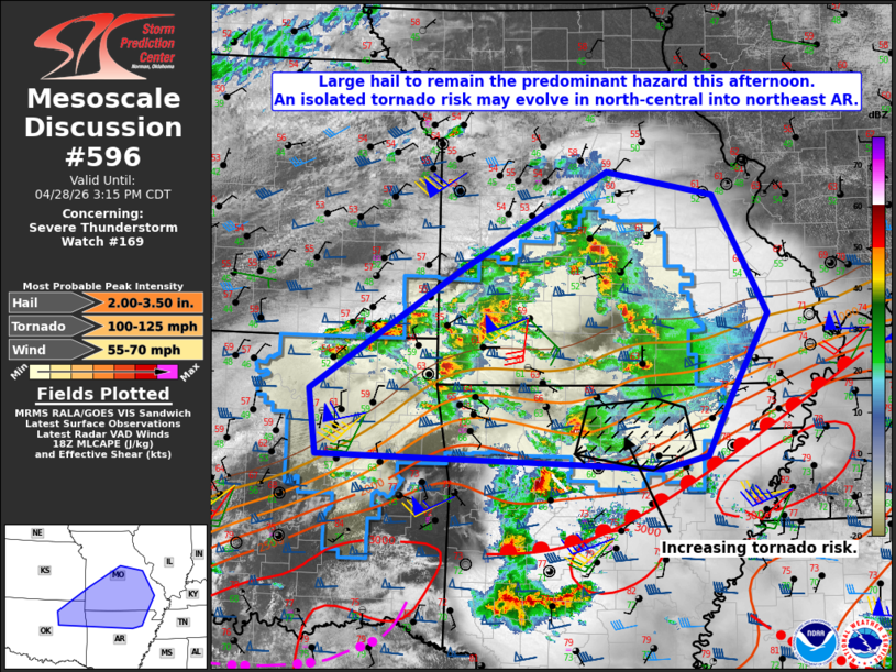 | |
Mesoscale Discussion 0596 NWS Storm Prediction Center Norman OK 0108 PM CDT Tue Apr 28 2026 Areas affected...northeast Oklahoma into central and southern Missouri and northern Arkansas Concerning...Severe Thunderstorm Watch 169... Valid 281808Z - 282015Z The severe weather threat for Severe Thunderstorm Watch 169 continues. SUMMARY...Large hail is expected to remain the predominant severe-weather hazard across the watch area this afternoon. That threat is expected to spread east/northeast of the existing watch, and an additional Severe Thunderstorm Watch will likely be required. Elsewhere, increasing tornado risk may materialize across portions of north-central into northeast Arkansas. DISCUSSION...A number of supercells, both right- and left-moving, have developed across the watch area with hail up to 3.25" in diameter being reported. A combination of low-level warm advection and increased DCVA downstream from a short-wave trough moving through KS are driving this convective activity. Given the progressive nature of the short-wave trough, the storms are expected to spread east/northeast of Severe Thunderstorm Watch 169, likely necessitating an additional downstream watch. The majority of the storms appear to be elevated atop a boundary layer with temperatures in the 50s and 60s at most locations. However, filtered sunshine across portions of north-central into northeast AR has allowed temperatures to warm into the 70s. Moreover, the surface front in place across central into northeast AR appears to be slowly lifting north with dewpoints increasing into the mid 60s to the north of the boundary. Current thinking is that the supercell ongoing in Searcy County, AR will become increasingly surface-based as it continues east into the warming/moistening boundary layer. Ahead of that storm, RAP forecast soundings indicate gradually strengthening low-level shear in response to a strengthening low-level jet across AR. The net result is an increasing concern for a couple tornadoes in parts of north-central into northeast AR this afternoon. An areal extension of Tornado Watch #170 may become necessary to accommodate that threat. ..Mead.. 04/28/2026 ...Please see www.spc.noaa.gov for graphic product... ATTN...WFO...PAH...MEG...LSX...LZK...SGF...TSA...ICT... LAT...LON 35729623 36439634 37729434 38829232 38559086 37259014 36359064 35729097 35579157 35729623 MOST PROBABLE PEAK TORNADO INTENSITY...100-125 MPH MOST PROBABLE PEAK WIND GUST...55-70 MPH MOST PROBABLE PEAK HAIL SIZE...2.00-3.50 IN | |
| Top/All Mesoscale Discussions/Forecast Products/Home | |