|
|
| Mesoscale Discussion 578 | |
| Next MD > | |
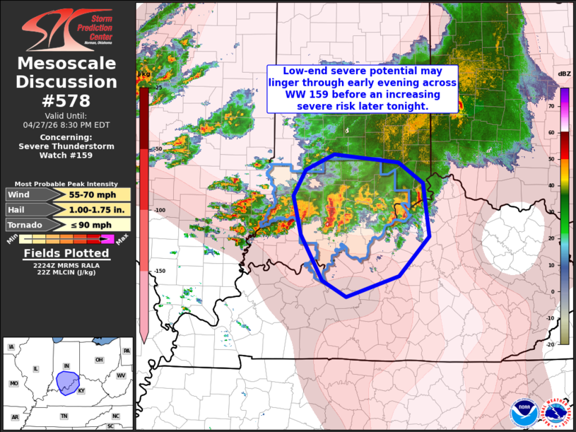 | |
Mesoscale Discussion 0578 NWS Storm Prediction Center Norman OK 0526 PM CDT Mon Apr 27 2026 Areas affected...southern IN into north-central KY Concerning...Severe Thunderstorm Watch 159... Valid 272226Z - 280030Z The severe weather threat for Severe Thunderstorm Watch 159 continues. SUMMARY...Isolated strong thunderstorms may persist for a few hours late this afternoon/early this evening, posing mainly a risk for hail and gusty winds. However, the severe risk may increase again later tonight. DISCUSSION...Convection is ongoing across southern IN along outflow north of the Ohio River. Training convection and cloud cover extending southward in central KY is limiting instability and resulting in at least weak inhibition. Some lingering risk for marginally severe hail and gusty winds is expected over the next few hours. Later this evening into tonight, airmass recovery is expected as stronger warm advection overspreads the lower OH Valley and a cold front approaching the Mid-MS Valley advances eastward. A relative lull in severe potential may develop in the short term due to convective contamination. Severe Thunderstorm Watch 159 could be locally extended to cover the short term marginal severe potential. However, increasing severe potential will likely have to be addressed later this evening across portions of the region. ..Leitman.. 04/27/2026 ...Please see www.spc.noaa.gov for graphic product... ATTN...WFO...ILN...LMK...IND...PAH... LAT...LON 39018496 38298486 37758538 37478628 37698668 38328706 38848719 39188698 39398649 39298538 39018496 MOST PROBABLE PEAK TORNADO INTENSITY...UP TO 90 MPH MOST PROBABLE PEAK WIND GUST...55-70 MPH MOST PROBABLE PEAK HAIL SIZE...1.00-1.75 IN | |
| Top/All Mesoscale Discussions/Forecast Products/Home | |