|
|
| Mesoscale Discussion 574 | |
| Next MD > | |
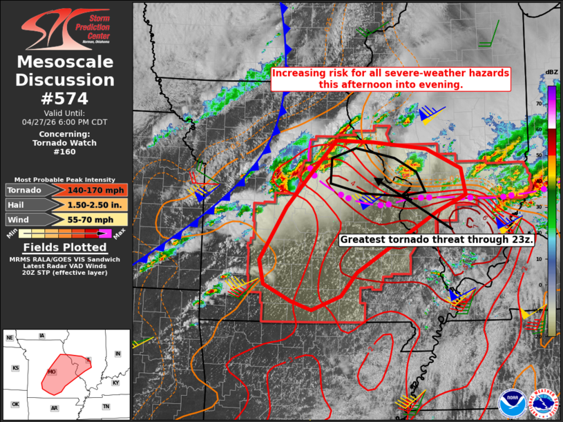 | |
Mesoscale Discussion 0574 NWS Storm Prediction Center Norman OK 0355 PM CDT Mon Apr 27 2026 Areas affected...south-central through east-central Missouri into southwest Illinois Concerning...Tornado Watch 160... Valid 272055Z - 272300Z The severe weather threat for Tornado Watch 160 continues. SUMMARY...The threat for all severe-weather hazards --including the potential for strong tornadoes-- is expected to increase late this afternoon into evening. DISCUSSION...Recent trends in surface observations and radar data indicate the outflow boundary south of the St. Louis metropolitan area stalling with the western extent of that feature lifting north in the Columbia, MO vicinity. PBL warming and moistening to the north of the modifying boundary is resulting in rapid air mass recovery within a kinematic environment featuring locally backed surface winds with As such, rapid air mass recovery is ongoing along to the north of the retreating outflow, which is coincident with a corridor of enhanced low-level shear with effective SRH of 200-300 M2/s2. The supercell ongoing to the immediate north of the St. Louis metro is within the eastern fringe of the stronger destabilization amidst a kinematic environment featuring around 250 m2/s2 of effective SRH and around 60 kt of effective bulk shear. As such, the potential for tornadoes will exist with that storm, at least in the near-term. The longer-term tornado threat with that storm will be contingent on sufficient destabilization of the downstream air mass to the north of the fresher segment of convective outflow. At the same time, thunderstorms are increasing in areal coverage along and ahead of a cold front moving through northwest and west-central MO, where low-level winds have veered to southwesterly. The leading edge of those storms will pose the greatest risk for tornadoes as the continue northeast and encounter increasingly stronger low-level shear near and to the north of the Columbia and Mexico, MO vicinities. In addition to the tornado threat, the potential for large to very large hail will exist with any sustained supercells. Isolated damaging wind gusts also remain possible. ..Mead.. 04/27/2026 ...Please see www.spc.noaa.gov for graphic product... ATTN...WFO...ILX...LSX...SGF... LAT...LON 37549338 38449280 39039228 39589173 39559093 39448977 39108902 38648892 38378953 37929032 37339128 36939162 36699225 36849270 37149328 37549338 MOST PROBABLE PEAK TORNADO INTENSITY...140-170 MPH MOST PROBABLE PEAK WIND GUST...55-70 MPH MOST PROBABLE PEAK HAIL SIZE...1.50-2.50 IN | |
| Top/All Mesoscale Discussions/Forecast Products/Home | |