
|
|
| Mesoscale Discussion 562 | |
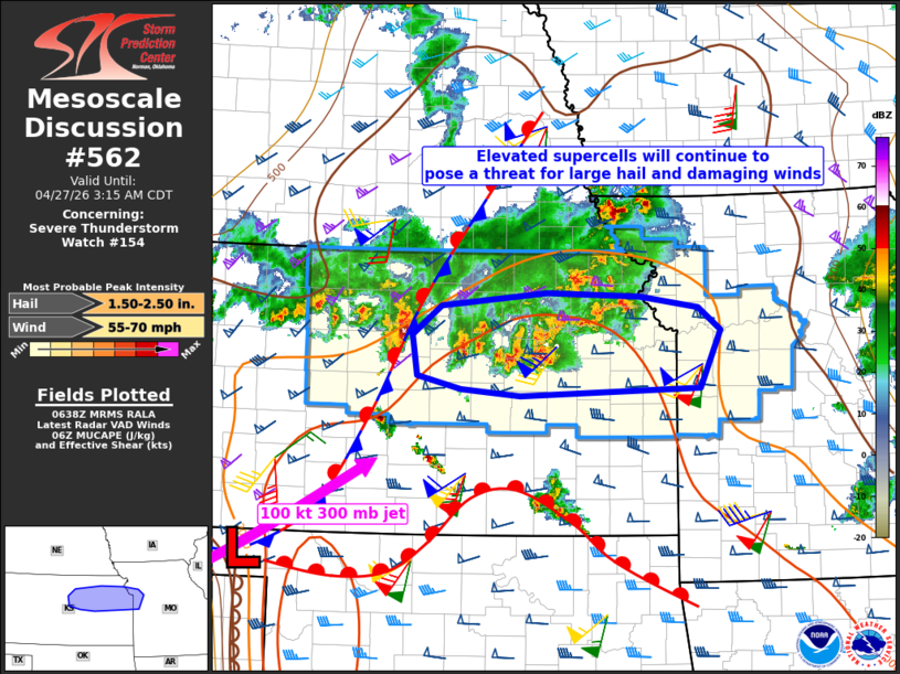 | |
Mesoscale Discussion 0562 NWS Storm Prediction Center Norman OK 0139 AM CDT Mon Apr 27 2026 Areas affected...I-70 corridor from northern Kansas into northwest Missouri Concerning...Severe Thunderstorm Watch 154... Valid 270639Z - 270815Z The severe weather threat for Severe Thunderstorm Watch 154 continues. SUMMARY...Elevated supercells will continue to pose a large hail and isolated damaging wind threat while spreading eastward along the I-70 corridor. DISCUSSION...Clusters of elevated supercells, with a recent history of hail up to 2 inches in diameter, continue to spread eastward along the I-70 corridor in north central and northeast KS. This area is within the left-exit region of a 100 kt jet at 300 mb, and along the north edge of the steep midlevel lapse rates where strong low-level warm advection is ongoing. The updrafts appear to be rooted near 850 mb with MUCAPE near 3000 J/kg. The combination of large buoyancy and strong cloud-layer/effective shear will continue to favor supercells capable of producing very large hail (near or above 2 inches in diameter). These storms will also be capable of producing isolated wind damage given the steep midlevel lapse rates and moderately large DCAPE. ..Thompson.. 04/27/2026 ...Please see www.spc.noaa.gov for graphic product... ATTN...WFO...EAX...TOP...ICT...GID... LAT...LON 38479671 38539751 38689810 39109816 39419777 39559634 39529510 39409430 39159400 38559428 38479671 MOST PROBABLE PEAK WIND GUST...55-70 MPH MOST PROBABLE PEAK HAIL SIZE...1.50-2.50 IN | |
| Top/All Mesoscale Discussions/Forecast Products/Home | |