|
|
| Mesoscale Discussion 467 | |
| Next MD > | |
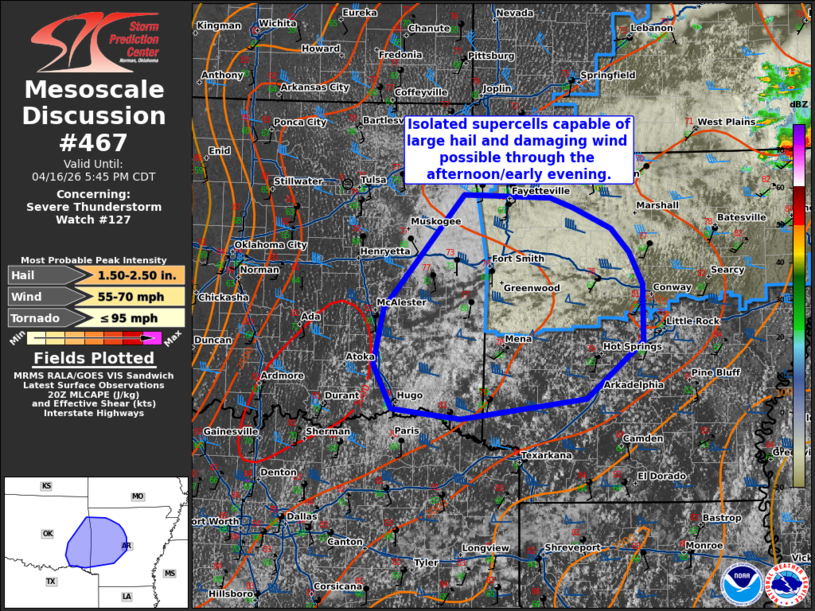 | |
Mesoscale Discussion 0467 NWS Storm Prediction Center Norman OK 0346 PM CDT Thu Apr 16 2026 Areas affected...eastern Oklahoma into western Arkansas Concerning...Severe Thunderstorm Watch 127... Valid 162046Z - 162245Z CORRECTED FOR ERROR IN TEXT The severe weather threat for Severe Thunderstorm Watch 127 continues. SUMMARY...Isolated risk for supercells capable of large hail and damaging wind through the late afternoon/evening. DISCUSSION...Deepening cumulus has been noted across southeastern OK over the last 1-2 hours. Forcing in this region is generally weak, with the shortwave trough to the north and dry mid-level air noted in water vapor imagery. Nonetheless, strong daytime heating has occurred (with temperature in the 80s). This in combination with dew points in the upper 60s to 70s has yielded MLCAPE around 2500-3000 J/kg amid strong deep layer shear around 40 kts. Guidance suggests that an isolated supercell or two could develop within this region. Conditionally, these would support a risk for large hail and damaging wind. This area will be monitored for potential development and need for watch extension. ..Thornton.. 04/16/2026 ...Please see www.spc.noaa.gov for graphic product... ATTN...WFO...LZK...SHV...TSA... LAT...LON 34619254 35199253 35509269 35759291 35959338 36059366 36099470 34949555 34389566 33959558 33889508 33849473 34049323 34619254 MOST PROBABLE PEAK TORNADO INTENSITY...UP TO 95 MPH MOST PROBABLE PEAK WIND GUST...55-70 MPH MOST PROBABLE PEAK HAIL SIZE...1.50-2.50 IN | |
| Top/All Mesoscale Discussions/Forecast Products/Home | |