|
|
| Mesoscale Discussion 462 | |
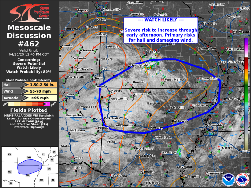 | |
   Mesoscale Discussion 0462
   NWS Storm Prediction Center Norman OK
   1140 AM CDT Thu Apr 16 2026

   Areas affected...southern Missouri...northern Arkansas...portions of
   western Tennessee/Kentucky

   Concerning...Severe potential...Watch likely

   Valid 161640Z - 161745Z

   CORRECTED FOR MISSING TEXT

   Probability of Watch Issuance...80 percent

   SUMMARY...Severe risk to increase through the early afternoon.
   Primary risks will include large hail and damaging wind.

   DISCUSSION...Visible satellite across southern Missouri shows an
   area of deepening cu development, with a few smaller cells with
   occasional lightning developing east of Springfield. The 12z RAOB
   from SGF (Springfield, MO) shows MLCIN in place, which can still be
   observed in surface objective analysis. With additional
   heating/mixing and cooling aloft with the approaching shortwave,
   this is expected to erode over the next couple of hours.

   HREF guidance suggests that a cluster of thunderstorms may develop
   by early afternoon before moving south and eastward into northern
   Arkansas as forcing for ascent increases. Forecast soundings depict
   linearly elongated hodographs and steep low to mid-level lapse
   rates, favorable for supercells capable of large hail. Through time,
   it is likely that storms will cluster with an increase in damaging
   wind potential. Additional thunderstorms will be possible near the
   OK/AR border this afternoon. A watch will likely be needed to cover
   these threats.

   ..Thornton/Mosier.. 04/16/2026

   ...Please see www.spc.noaa.gov for graphic product...

   ATTN...WFO...PAH...MEG...LSX...LZK...SGF...TSA...

   LAT...LON   35679001 35269132 34989266 35009340 35079404 35239437
               35589446 36039459 36599456 37359301 37349293 37459249
               37499175 37499137 37139014 36728949 36018957 35679001

   MOST PROBABLE PEAK TORNADO INTENSITY...UP TO 95 MPH
   MOST PROBABLE PEAK WIND GUST...55-70 MPH
   MOST PROBABLE PEAK HAIL SIZE...1.50-2.50 IN
| |
| Top/All Mesoscale Discussions/Forecast Products/Home | |