|
|
| Mesoscale Discussion 457 | |
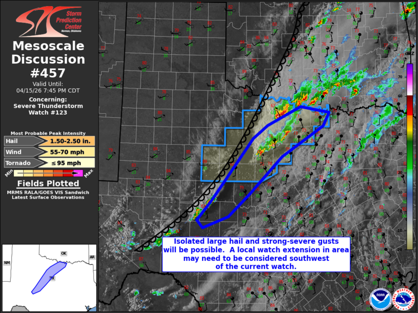 | |
Mesoscale Discussion 0457 NWS Storm Prediction Center Norman OK 0618 PM CDT Wed Apr 15 2026 Areas affected...North and central Texas Concerning...Severe Thunderstorm Watch 123... Valid 152318Z - 160045Z The severe weather threat for Severe Thunderstorm Watch 123 continues. SUMMARY...Large hail and isolated wind damage threat will continue with storm clusters/supercells across north Texas, and additional cluster development is possible into central Texas (where an extension in area might need to be considered). DISCUSSION...Storms are ongoing in clusters with some embedded supercells along a conglomerate outflow from Stephens into Jack Cos. These storms are in the corridor of greatest buoyancy now, with gradual buoyancy decrease with eastward extent as a result of thicker cloud cover. A continuation of MLCAPE of 2000-2500 J/kg with relatively long/straight hodographs will support supercells with large hail and isolated wind damage in a cluster-type mode for the next couple of hours, given the more SW-NE orientation of the dryline and storm-scale outflows. The new updraft development farther southwest to near SJT could necessitate an extension to roughly Tom Green and Concho Cos. in the next 30 minutes. ..Thompson.. 04/15/2026 ...Please see www.spc.noaa.gov for graphic product... ATTN...WFO...FWD...OUN...SJT... LAT...LON 33459874 33929777 33769693 33439710 32699832 31769926 31209987 30920059 31110077 31620034 33149915 33459874 MOST PROBABLE PEAK TORNADO INTENSITY...UP TO 95 MPH MOST PROBABLE PEAK WIND GUST...55-70 MPH MOST PROBABLE PEAK HAIL SIZE...1.50-2.50 IN | |
| Top/All Mesoscale Discussions/Forecast Products/Home | |