|
|
| Mesoscale Discussion 438 | |
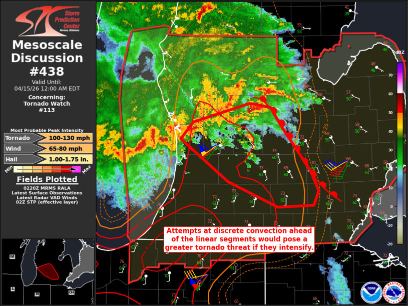 | |
Mesoscale Discussion 0438 NWS Storm Prediction Center Norman OK 0923 PM CDT Tue Apr 14 2026 Areas affected...Central into southern Lower Michigan Concerning...Tornado Watch 113... Valid 150223Z - 150400Z The severe weather threat for Tornado Watch 113 continues. SUMMARY...Aside from damaging winds and isolated large hail, discrete storms near the warm front will pose the greatest tornado risk if they can intensify. DISCUSSION...Discrete convection has been noted ahead of the linear segments moving southeastward off of Lake Michigan. Given their proximity to the warm front and the large SRH on KGRR VAD (over 400 0-1 km), these storms will pose the greatest risk for tornadoes should they intensify. A strong tornado is possible within this environment. ..Wendt.. 04/15/2026 ...Please see www.spc.noaa.gov for graphic product... ATTN...WFO...DTX...GRR... LAT...LON 42958614 43158594 43378504 43358493 43318470 43088452 42588408 42348394 42178403 42158460 42458538 42958614 MOST PROBABLE PEAK TORNADO INTENSITY...100-130 MPH MOST PROBABLE PEAK WIND GUST...65-80 MPH MOST PROBABLE PEAK HAIL SIZE...1.00-1.75 IN | |
| Top/All Mesoscale Discussions/Forecast Products/Home | |