|
|
| Mesoscale Discussion 432 | |
| Next MD > | |
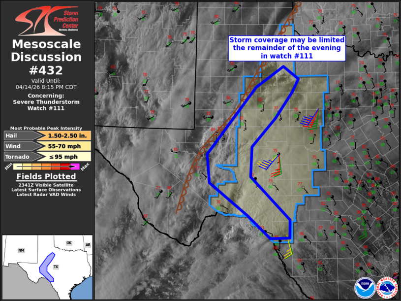 | |
Mesoscale Discussion 0432 NWS Storm Prediction Center Norman OK 0646 PM CDT Tue Apr 14 2026 Areas affected...The Big Country and Edwards Plateau of Texas Concerning...Severe Thunderstorm Watch 111... Valid 142346Z - 150115Z The severe weather threat for Severe Thunderstorm Watch 111 continues. SUMMARY...Storm coverage in WW #111 will likely be limited the remainder of the evening. DISCUSSION...Satellite imagery and surface observations show widespread clouds east of a dryline, with relatively cool surface temperatures mostly in the the 70s. Thunderstorms have developed recently along the retreating dryline just southwest of Midland. However, these storms may struggle to persist, and new storm development will be limited as a result of lingering convective inhibition this evening from the Edwards Plateau into the Big Country. Farther south, there is some potential for a supercell to cross the Rio Grande and make it into Val Verde Co. (near Del Rio) 00-01z, with an attendant threat for large hail and severe outflow gusts. Given the questions about storm intensity/persistence across much of WW #111, some/most of the watch could be removed near and after 01z. ..Thompson.. 04/14/2026 ...Please see www.spc.noaa.gov for graphic product... ATTN...WFO...OUN...EWX...SJT...LUB...MAF... LAT...LON 31360266 33110116 33650032 33319985 32980005 32290058 31560129 30780134 29650016 29190017 29180075 29770143 30620258 31360266 MOST PROBABLE PEAK TORNADO INTENSITY...UP TO 95 MPH MOST PROBABLE PEAK WIND GUST...55-70 MPH MOST PROBABLE PEAK HAIL SIZE...1.50-2.50 IN | |
| Top/All Mesoscale Discussions/Forecast Products/Home | |