|
|
| Mesoscale Discussion 1001 | |
| Next MD > | |
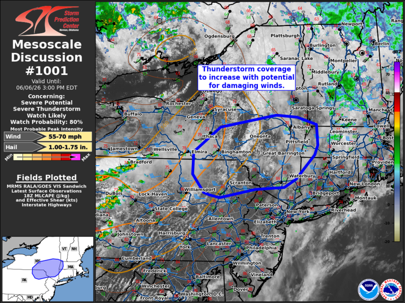 | |
   Mesoscale Discussion 1001
   NWS Storm Prediction Center Norman OK
   0103 PM CDT Sat Jun 06 2026

   Areas affected...northeastern Pennsylvania into southeastern New
   York

   Concerning...Severe potential...Severe Thunderstorm Watch likely

   Valid 061803Z - 061900Z

   Probability of Watch Issuance...80 percent

   SUMMARY...Thunderstorms to increase in coverage through the
   afternoon with increasing potential for damaging winds.

   DISCUSSION...Thunderstorms are expected to develop and increase in
   coverage through the afternoon across portions of northeastern PA
   into southern NY, with potential for ongoing clusters across
   northern PA to expand eastward. Recent mesoanalysis shows
   temperatures have warmed into the upper 70s to 80s with MLCAPE
   around 500-1000 J/kg nudging into the region. Warm and unstable
   conditions amid steep low-level lapse rates will promote risk for
   downward momentum transfer of stronger winds aloft with the
   mid-level wave to the north. A watch will likely be needed to
   support this potential over the next 1-2 hours.

   ..Thornton/Thompson.. 06/06/2026

   ...Please see www.spc.noaa.gov for graphic product...

   ATTN...WFO...BOX...OKX...ALY...PHI...BGM...CTP...

   LAT...LON   42177670 41677672 41257638 41207622 41157591 41337484
               41377399 41557364 42107308 42327298 42787301 42947359
               42997422 42727590 42177670

   MOST PROBABLE PEAK WIND GUST...55-70 MPH
   MOST PROBABLE PEAK HAIL SIZE...1.00-1.75 IN
| |
| Top/All Mesoscale Discussions/Forecast Products/Home | |