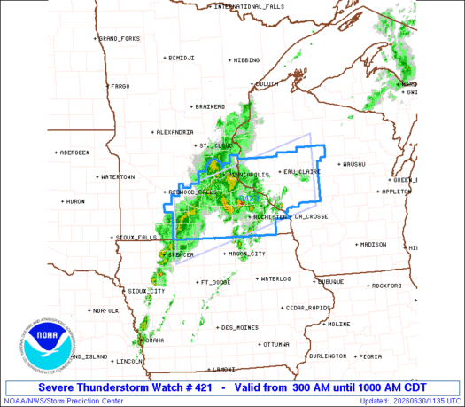
Note:
The expiration time in the watch graphic is amended if the watch is
replaced, cancelled or extended.
Note: Click for Watch Status Reports.
   SEL1

   URGENT - IMMEDIATE BROADCAST REQUESTED
   Severe Thunderstorm Watch Number 421
   NWS Storm Prediction Center Norman OK
   300 AM CDT Tue Jun 30 2026

   The NWS Storm Prediction Center has issued a

   * Severe Thunderstorm Watch for portions of
     Northern Iowa
     Southern and Southeast Minnesota
     Western and West-Central Wisconsin

   * Effective this Tuesday morning from 300 AM until 1000 AM CDT.

   * Primary threats include...
     Scattered damaging winds and isolated significant gusts to 75
       mph possible
     Isolated large hail events to 1 inch in diameter possible

   SUMMARY...A cluster of severe thunderstorms will move into the Watch
   area tonight and likely move east-northeast across the Watch area
   through the early to mid morning.  The linear cluster will pose a
   risk for scattered severe gusts (60 to 75 mph).

   The severe thunderstorm watch area is approximately along and 55
   statute miles north and south of a line from 20 miles west northwest
   of Fairmont MN to 50 miles east of Eau Claire WI. For a complete
   depiction of the watch see the associated watch outline update
   (WOUS64 KWNS WOU1).

   PRECAUTIONARY/PREPAREDNESS ACTIONS...

   REMEMBER...A Severe Thunderstorm Watch means conditions are
   favorable for severe thunderstorms in and close to the watch area.
   Persons in these areas should be on the lookout for threatening
   weather conditions and listen for later statements and possible
   warnings. Severe thunderstorms can and occasionally do produce
   tornadoes.

   &&

   OTHER WATCH INFORMATION...CONTINUE...WW 420...

   AVIATION...A few severe thunderstorms with hail surface and aloft to
   1 inch. Extreme turbulence and surface wind gusts to 65 knots. A few
   cumulonimbi with maximum tops to 550. Mean storm motion vector
   24045.

   ...Smith

Note:
The Aviation Watch (SAW) product is an approximation to the watch area.
The actual watch is depicted by the shaded areas.
   SAW1
   WW 421 SEVERE TSTM IA MN WI 300800Z - 301500Z
   AXIS..55 STATUTE MILES NORTH AND SOUTH OF LINE..
   20WNW FRM/FAIRMONT MN/ - 50E EAU/EAU CLAIRE WI/
   ..AVIATION COORDS.. 50NM N/S /45SSE RWF - 43E EAU/
   HAIL SURFACE AND ALOFT..1 INCH. WIND GUSTS..65 KNOTS.
   MAX TOPS TO 550. MEAN STORM MOTION VECTOR 24045.

   LAT...LON 44569479 45669046 44079046 42969479

   THIS IS AN APPROXIMATION TO THE WATCH AREA.  FOR A
   COMPLETE DEPICTION OF THE WATCH SEE WOUS64 KWNS
   FOR WOU1.
Watch 421 Status Report Messages:
STATUS REPORT #1 ON WW 421

VALID 301035Z - 301140Z

THE SEVERE WEATHER THREAT CONTINUES ACROSS THE ENTIRE WATCH AREA.

..DEAN..06/30/26

ATTN...WFO...DMX...MPX...ARX...

&&

STATUS REPORT FOR WS 421

SEVERE WEATHER THREAT CONTINUES FOR THE FOLLOWING AREAS

IAC063-109-147-189-195-301140-

IA
.    IOWA COUNTIES INCLUDED ARE

EMMET		     KOSSUTH		 PALO ALTO
WINNEBAGO	     WORTH
$$


MNC013-015-019-037-039-043-045-047-049-053-079-091-099-103-109-
123-131-139-143-147-157-161-163-165-169-301140-

MN
.    MINNESOTA COUNTIES INCLUDED ARE

BLUE EARTH	     BROWN		 CARVER
DAKOTA		     DODGE		 FARIBAULT
FILLMORE	     FREEBORN		 GOODHUE
HENNEPIN	     LE SUEUR		 MARTIN
MOWER		     NICOLLET		 OLMSTED
RAMSEY		     RICE		 SCOTT
SIBLEY		     STEELE		 WABASHA
WASECA		     WASHINGTON 	 WATONWAN
WINONA
$$


WIC011-017-019-033-035-053-091-093-109-119-121-301140-

WI
.    WISCONSIN COUNTIES INCLUDED ARE

BUFFALO 	     CHIPPEWA		 CLARK
DUNN		     EAU CLAIRE 	 JACKSON
PEPIN		     PIERCE		 ST. CROIX
TAYLOR		     TREMPEALEAU
$$


THE WATCH STATUS MESSAGE IS FOR GUIDANCE PURPOSES ONLY.  PLEASE
REFER TO WATCH COUNTY NOTIFICATION STATEMENTS FOR OFFICIAL
INFORMATION ON COUNTIES...INDEPENDENT CITIES AND MARINE ZONES
CLEARED FROM SEVERE THUNDERSTORM AND TORNADO WATCHES.
$$

Note:
Click for Complete Product Text.
Tornadoes
| Probability of 2 or more tornadoes |
Low (10%) |
| Probability of 1 or more strong (EF2-EF5) tornadoes |
Low ( |
Wind
| Probability of 10 or more severe wind events |
Mod (50%) |
| Probability of 1 or more wind events > 65 knots |
Mod (30%) |
Hail
| Probability of 10 or more severe hail events |
Mod (30%) |
| Probability of 1 or more hailstones > 2 inches |
Low (20%) |
Combined Severe Hail/Wind
| Probability of 6 or more combined severe hail/wind events |
High (80%) |
For each watch, probabilities for particular events inside the watch
(listed above in each table) are determined by the issuing forecaster.
The “Low” category contains probability values ranging from less than 2%
to 20% (EF2-EF5 tornadoes), less than 5% to 20% (all other probabilities),
“Moderate” from 30% to 60%, and “High” from 70% to greater than 95%.
High values are bolded and lighter in color to provide awareness of
an increased threat for a particular event.