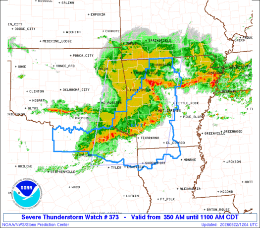
Note:
The expiration time in the watch graphic is amended if the watch is
replaced, cancelled or extended.
Note: Click for Watch Status Reports.
   SEL3

   URGENT - IMMEDIATE BROADCAST REQUESTED
   Severe Thunderstorm Watch Number 373
   NWS Storm Prediction Center Norman OK
   350 AM CDT Mon Jun 22 2026

   The NWS Storm Prediction Center has issued a

   * Severe Thunderstorm Watch for portions of
     Western and Central Arkansas
     Northern Louisiana
     Eastern Oklahoma
     North-Central and Northeast Texas

   * Effective this Monday morning from 350 AM until 1100 AM CDT.

   * Primary threats include...
     Scattered damaging winds likely with isolated significant gusts
       to 75 mph possible
     A tornado or two possible

   SUMMARY...A well-organized bowing thunderstorm complex will likely
   continue to pose a threat for scattered to numerous damaging winds
   as it tracks quickly east-southeastward this morning. Peak gusts may
   reach up to 65-75 mph on an isolated basis, and a brief tornado or
   two is also possible.

   The severe thunderstorm watch area is approximately along and 100
   statute miles east and west of a line from 40 miles west of
   Shreveport LA to 25 miles northwest of Harrison AR. For a complete
   depiction of the watch see the associated watch outline update
   (WOUS64 KWNS WOU3).

   PRECAUTIONARY/PREPAREDNESS ACTIONS...

   REMEMBER...A Severe Thunderstorm Watch means conditions are
   favorable for severe thunderstorms in and close to the watch area.
   Persons in these areas should be on the lookout for threatening
   weather conditions and listen for later statements and possible
   warnings. Severe thunderstorms can and occasionally do produce
   tornadoes.

   &&

   OTHER WATCH INFORMATION...CONTINUE...WW 372...

   AVIATION...A few severe thunderstorms with hail surface and aloft to
   1 inch. Extreme turbulence and surface wind gusts to 65 knots. A few
   cumulonimbi with maximum tops to 550. Mean storm motion vector
   30045.

   ...Gleason

   SEL3

   URGENT - IMMEDIATE BROADCAST REQUESTED
   Severe Thunderstorm Watch Number 373
   NWS Storm Prediction Center Norman OK
   350 AM CDT Mon Jun 22 2026

   The NWS Storm Prediction Center has issued a

   * Severe Thunderstorm Watch for portions of
     Western and Central Arkansas
     Northern Louisiana
     Eastern Oklahoma
     North-Central and Northeast Texas

   * Effective this Monday morning from 350 AM until 1100 AM CDT.

   * Primary threats include...
     Scattered damaging winds likely with isolated significant gusts
       to 75 mph possible
     A tornado or two possible

   SUMMARY...A well-organized bowing thunderstorm complex will likely
   continue to pose a threat for scattered to numerous damaging winds
   as it tracks quickly east-southeastward this morning. Peak gusts may
   reach up to 65-75 mph on an isolated basis, and a brief tornado or
   two is also possible.

   The severe thunderstorm watch area is approximately along and 100
   statute miles east and west of a line from 40 miles west of
   Shreveport LA to 25 miles northwest of Harrison AR. For a complete
   depiction of the watch see the associated watch outline update
   (WOUS64 KWNS WOU3).

   PRECAUTIONARY/PREPAREDNESS ACTIONS...

   REMEMBER...A Severe Thunderstorm Watch means conditions are
   favorable for severe thunderstorms in and close to the watch area.
   Persons in these areas should be on the lookout for threatening
   weather conditions and listen for later statements and possible
   warnings. Severe thunderstorms can and occasionally do produce
   tornadoes.

   &&

   OTHER WATCH INFORMATION...CONTINUE...WW 372...

   AVIATION...A few severe thunderstorms with hail surface and aloft to
   1 inch. Extreme turbulence and surface wind gusts to 65 knots. A few
   cumulonimbi with maximum tops to 550. Mean storm motion vector
   30045.

   ...Gleason

Note:
The Aviation Watch (SAW) product is an approximation to the watch area.
The actual watch is depicted by the shaded areas.
   SAW3
   WW 373 SEVERE TSTM AR LA OK TX 220850Z - 221600Z
   AXIS..100 STATUTE MILES EAST AND WEST OF LINE..
   40W SHV/SHREVEPORT LA/ - 25NW HRO/HARRISON AR/
   ..AVIATION COORDS.. 85NM E/W /12E GGG - 36ENE RZC/
   HAIL SURFACE AND ALOFT..1 INCH. WIND GUSTS..65 KNOTS.
   MAX TOPS TO 550. MEAN STORM MOTION VECTOR 30045.

   LAT...LON 32439623 36509527 36509167 32439280

   THIS IS AN APPROXIMATION TO THE WATCH AREA.  FOR A
   COMPLETE DEPICTION OF THE WATCH SEE WOUS64 KWNS
   FOR WOU3.
Watch 373 Status Report Messages:
STATUS REPORT #1 ON WW 373

VALID 221115Z - 221240Z

SEVERE WEATHER THREAT CONTINUES RIGHT OF A LINE FROM 45 SE SPS TO
15 SW GYI TO 25 NNW PRX TO 30 NNW DEQ TO 25 ESE RKR TO 10 ESE FSM
TO 25 N FSM TO 25 N FYV.

..BUNTING..06/22/26

ATTN...WFO...LZK...TSA...SHV...FWD...

&&

STATUS REPORT FOR WS 373

SEVERE WEATHER THREAT CONTINUES FOR THE FOLLOWING AREAS

ARC005-009-013-019-023-027-029-039-045-047-051-053-057-059-061-
071-073-081-083-087-089-091-097-099-101-103-105-109-113-115-119-
125-127-129-133-137-139-141-149-221240-

AR
.    ARKANSAS COUNTIES INCLUDED ARE

BAXTER		     BOONE		 CALHOUN
CLARK		     CLEBURNE		 COLUMBIA
CONWAY		     DALLAS		 FAULKNER
FRANKLIN	     GARLAND		 GRANT
HEMPSTEAD	     HOT SPRING 	 HOWARD
JOHNSON 	     LAFAYETTE		 LITTLE RIVER
LOGAN		     MADISON		 MARION
MILLER		     MONTGOMERY 	 NEVADA
NEWTON		     OUACHITA		 PERRY
PIKE		     POLK		 POPE
PULASKI 	     SALINE		 SCOTT
SEARCY		     SEVIER		 STONE
UNION		     VAN BUREN		 YELL
$$


LAC015-017-027-111-119-221240-

LA
.    LOUISIANA PARISHES INCLUDED ARE

BOSSIER 	     CADDO		 CLAIBORNE
UNION		     WEBSTER
$$


TXC037-063-067-085-119-121-147-159-203-223-231-277-315-343-379-
387-449-459-497-499-221240-

TX
.    TEXAS COUNTIES INCLUDED ARE

BOWIE		     CAMP		 CASS
COLLIN		     DELTA		 DENTON
FANNIN		     FRANKLIN		 HARRISON
HOPKINS 	     HUNT		 LAMAR
MARION		     MORRIS		 RAINS
RED RIVER	     TITUS		 UPSHUR
WISE		     WOOD
$$


THE WATCH STATUS MESSAGE IS FOR GUIDANCE PURPOSES ONLY.  PLEASE
REFER TO WATCH COUNTY NOTIFICATION STATEMENTS FOR OFFICIAL
INFORMATION ON COUNTIES...INDEPENDENT CITIES AND MARINE ZONES
CLEARED FROM SEVERE THUNDERSTORM AND TORNADO WATCHES.
$$

Note:
Click for Complete Product Text.
Tornadoes
| Probability of 2 or more tornadoes |
Low (20%) |
| Probability of 1 or more strong (EF2-EF5) tornadoes |
Low ( |
Wind
| Probability of 10 or more severe wind events |
High (70%) |
| Probability of 1 or more wind events > 65 knots |
Mod (40%) |
Hail
| Probability of 10 or more severe hail events |
Low ( |
| Probability of 1 or more hailstones > 2 inches |
Low ( |
Combined Severe Hail/Wind
| Probability of 6 or more combined severe hail/wind events |
High (80%) |
For each watch, probabilities for particular events inside the watch
(listed above in each table) are determined by the issuing forecaster.
The “Low” category contains probability values ranging from less than 2%
to 20% (EF2-EF5 tornadoes), less than 5% to 20% (all other probabilities),
“Moderate” from 30% to 60%, and “High” from 70% to greater than 95%.
High values are bolded and lighter in color to provide awareness of
an increased threat for a particular event.