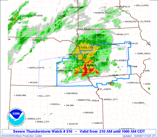
Note:
The expiration time in the watch graphic is amended if the watch is
replaced, cancelled or extended.
Note: Click for Watch Status Reports.
   SEL0

   URGENT - IMMEDIATE BROADCAST REQUESTED
   Severe Thunderstorm Watch Number 310
   NWS Storm Prediction Center Norman OK
   210 AM CDT Thu Jun 11 2026

   The NWS Storm Prediction Center has issued a

   * Severe Thunderstorm Watch for portions of
     Western and Central Iowa
     Northern Missouri
     South-Central and Eastern Nebraska

   * Effective this Thursday morning from 210 AM until 1000 AM CDT.

   * Primary threats include...
     Scattered large hail likely with isolated very large hail events
       to 3 inches in diameter possible
     Isolated damaging wind gusts to 70 mph possible
     A tornado or two possible

   SUMMARY...Mostly elevated strong to severe thunderstorms will
   continue to develop overnight, initially across
   south-central/eastern Nebraska, while eventually expanding into
   western/central Iowa and far northern Missouri. This will include
   the Interstate 80 corridor. Large hail is expected to be the most
   common hazard, but surface-based storm potential could increase
   mainly toward/after sunrise including what could be an increasing
   damaging wind risk.

   The severe thunderstorm watch area is approximately along and 60
   statute miles north and south of a line from 40 miles west of
   Kearney NE to 30 miles north of Ottumwa IA. For a complete depiction
   of the watch see the associated watch outline update (WOUS64 KWNS
   WOU0).

   PRECAUTIONARY/PREPAREDNESS ACTIONS...

   REMEMBER...A Severe Thunderstorm Watch means conditions are
   favorable for severe thunderstorms in and close to the watch area.
   Persons in these areas should be on the lookout for threatening
   weather conditions and listen for later statements and possible
   warnings. Severe thunderstorms can and occasionally do produce
   tornadoes.

   &&

   AVIATION...A few severe thunderstorms with hail surface and aloft to
   3 inches. Extreme turbulence and surface wind gusts to 60 knots. A
   few cumulonimbi with maximum tops to 550. Mean storm motion vector
   25025.

   ...Guyer

   SEL0

   URGENT - IMMEDIATE BROADCAST REQUESTED
   Severe Thunderstorm Watch Number 310
   NWS Storm Prediction Center Norman OK
   210 AM CDT Thu Jun 11 2026

   The NWS Storm Prediction Center has issued a

   * Severe Thunderstorm Watch for portions of
     Western and Central Iowa
     Northern Missouri
     South-Central and Eastern Nebraska

   * Effective this Thursday morning from 210 AM until 1000 AM CDT.

   * Primary threats include...
     Scattered large hail likely with isolated very large hail events
       to 3 inches in diameter possible
     Isolated damaging wind gusts to 70 mph possible
     A tornado or two possible

   SUMMARY...Mostly elevated strong to severe thunderstorms will
   continue to develop overnight, initially across
   south-central/eastern Nebraska, while eventually expanding into
   western/central Iowa and far northern Missouri. This will include
   the Interstate 80 corridor. Large hail is expected to be the most
   common hazard, but surface-based storm potential could increase
   mainly toward/after sunrise including what could be an increasing
   damaging wind risk.

   The severe thunderstorm watch area is approximately along and 60
   statute miles north and south of a line from 40 miles west of
   Kearney NE to 30 miles north of Ottumwa IA. For a complete depiction
   of the watch see the associated watch outline update (WOUS64 KWNS
   WOU0).

   PRECAUTIONARY/PREPAREDNESS ACTIONS...

   REMEMBER...A Severe Thunderstorm Watch means conditions are
   favorable for severe thunderstorms in and close to the watch area.
   Persons in these areas should be on the lookout for threatening
   weather conditions and listen for later statements and possible
   warnings. Severe thunderstorms can and occasionally do produce
   tornadoes.

   &&

   AVIATION...A few severe thunderstorms with hail surface and aloft to
   3 inches. Extreme turbulence and surface wind gusts to 60 knots. A
   few cumulonimbi with maximum tops to 550. Mean storm motion vector
   25025.

   ...Guyer

Note:
The Aviation Watch (SAW) product is an approximation to the watch area.
The actual watch is depicted by the shaded areas.
   SAW0
   WW 310 SEVERE TSTM IA MO NE 110710Z - 111500Z
   AXIS..60 STATUTE MILES NORTH AND SOUTH OF LINE..
   40W EAR/KEARNEY NE/ - 30N OTM/OTTUMWA IA/
   ..AVIATION COORDS.. 50NM N/S /49NE MCK - 38W IOW/
   HAIL SURFACE AND ALOFT..3 INCHES. WIND GUSTS..60 KNOTS.
   MAX TOPS TO 550. MEAN STORM MOTION VECTOR 25025.

   LAT...LON 41599976 42409245 40669245 39849976

   THIS IS AN APPROXIMATION TO THE WATCH AREA.  FOR A
   COMPLETE DEPICTION OF THE WATCH SEE WOUS64 KWNS
   FOR WOU0.
Watch 310 Status Report Messages:
STATUS REPORT #2 ON WW 310

VALID 111005Z - 111140Z

SEVERE WEATHER THREAT CONTINUES RIGHT OF A LINE FROM 35 WNW CNK
TO 40 SE ONL.

FOR ADDITIONAL INFORMATION SEE MESOSCALE DISCUSSION 1084

..WENDT..06/11/26

ATTN...WFO...DMX...OAX...EAX...GID...

&&

STATUS REPORT FOR WS 310

SEVERE WEATHER THREAT CONTINUES FOR THE FOLLOWING AREAS

IAC001-003-007-009-013-015-025-027-029-039-047-049-051-053-071-
073-075-077-079-083-085-099-117-121-123-125-127-129-133-135-137-
145-153-155-157-159-161-165-169-171-173-175-179-181-185-187-
111140-

IA
.    IOWA COUNTIES INCLUDED ARE

ADAIR		     ADAMS		 APPANOOSE
AUDUBON 	     BLACK HAWK 	 BOONE
CALHOUN 	     CARROLL		 CASS
CLARKE		     CRAWFORD		 DALLAS
DAVIS		     DECATUR		 FREMONT
GREENE		     GRUNDY		 GUTHRIE
HAMILTON	     HARDIN		 HARRISON
JASPER		     LUCAS		 MADISON
MAHASKA 	     MARION		 MARSHALL
MILLS		     MONONA		 MONROE
MONTGOMERY	     PAGE		 POLK
POTTAWATTAMIE	     POWESHIEK		 RINGGOLD
SAC		     SHELBY		 STORY
TAMA		     TAYLOR		 UNION
WAPELLO 	     WARREN		 WAYNE
WEBSTER
$$


MOC005-075-081-087-129-147-171-197-227-111140-

MO
.    MISSOURI COUNTIES INCLUDED ARE

ATCHISON	     GENTRY		 HARRISON
HOLT		     MERCER		 NODAWAY
PUTNAM		     SCHUYLER		 WORTH
$$


NEC021-023-025-035-037-053-055-059-067-081-095-097-109-121-125-
127-129-131-133-141-143-147-151-153-155-159-169-177-185-
111140-

NE
.    NEBRASKA COUNTIES INCLUDED ARE

BURT		     BUTLER		 CASS
CLAY		     COLFAX		 DODGE
DOUGLAS 	     FILLMORE		 GAGE
HAMILTON	     JEFFERSON		 JOHNSON
LANCASTER	     MERRICK		 NANCE
NEMAHA		     NUCKOLLS		 OTOE
PAWNEE		     PLATTE		 POLK
RICHARDSON	     SALINE		 SARPY
SAUNDERS	     SEWARD		 THAYER
WASHINGTON	     YORK
$$


THE WATCH STATUS MESSAGE IS FOR GUIDANCE PURPOSES ONLY.  PLEASE
REFER TO WATCH COUNTY NOTIFICATION STATEMENTS FOR OFFICIAL
INFORMATION ON COUNTIES...INDEPENDENT CITIES AND MARINE ZONES
CLEARED FROM SEVERE THUNDERSTORM AND TORNADO WATCHES.
$$

STATUS REPORT #1 ON WW 310

VALID 110830Z - 110940Z

THE SEVERE WEATHER THREAT CONTINUES ACROSS THE ENTIRE WATCH AREA.

FOR ADDITIONAL INFORMATION SEE MESOSCALE DISCUSSION 1083

..WENDT..06/11/26

ATTN...WFO...DMX...OAX...EAX...GID...

&&

STATUS REPORT FOR WS 310

SEVERE WEATHER THREAT CONTINUES FOR THE FOLLOWING AREAS

IAC001-003-007-009-013-015-025-027-029-039-047-049-051-053-071-
073-075-077-079-083-085-099-117-121-123-125-127-129-133-135-137-
145-153-155-157-159-161-165-169-171-173-175-179-181-185-187-
110940-

IA
.    IOWA COUNTIES INCLUDED ARE

ADAIR		     ADAMS		 APPANOOSE
AUDUBON 	     BLACK HAWK 	 BOONE
CALHOUN 	     CARROLL		 CASS
CLARKE		     CRAWFORD		 DALLAS
DAVIS		     DECATUR		 FREMONT
GREENE		     GRUNDY		 GUTHRIE
HAMILTON	     HARDIN		 HARRISON
JASPER		     LUCAS		 MADISON
MAHASKA 	     MARION		 MARSHALL
MILLS		     MONONA		 MONROE
MONTGOMERY	     PAGE		 POLK
POTTAWATTAMIE	     POWESHIEK		 RINGGOLD
SAC		     SHELBY		 STORY
TAMA		     TAYLOR		 UNION
WAPELLO 	     WARREN		 WAYNE
WEBSTER
$$


MOC005-075-081-087-129-147-171-197-227-110940-

MO
.    MISSOURI COUNTIES INCLUDED ARE

ATCHISON	     GENTRY		 HARRISON
HOLT		     MERCER		 NODAWAY
PUTNAM		     SCHUYLER		 WORTH
$$


NEC001-019-021-023-025-035-037-047-053-055-059-061-067-073-079-
081-093-095-097-099-109-121-125-127-129-131-133-137-141-143-147-
151-153-155-159-169-177-181-185-110940-

NE
.    NEBRASKA COUNTIES INCLUDED ARE

ADAMS		     BUFFALO		 BURT
BUTLER		     CASS		 CLAY
COLFAX		     DAWSON		 DODGE
DOUGLAS 	     FILLMORE		 FRANKLIN
GAGE		     GOSPER		 HALL
HAMILTON	     HOWARD		 JEFFERSON
JOHNSON 	     KEARNEY		 LANCASTER
MERRICK 	     NANCE		 NEMAHA
NUCKOLLS	     OTOE		 PAWNEE
PHELPS		     PLATTE		 POLK
RICHARDSON	     SALINE		 SARPY
SAUNDERS	     SEWARD		 THAYER
WASHINGTON	     WEBSTER		 YORK
$$


THE WATCH STATUS MESSAGE IS FOR GUIDANCE PURPOSES ONLY.  PLEASE
REFER TO WATCH COUNTY NOTIFICATION STATEMENTS FOR OFFICIAL
INFORMATION ON COUNTIES...INDEPENDENT CITIES AND MARINE ZONES
CLEARED FROM SEVERE THUNDERSTORM AND TORNADO WATCHES.
$$

Note:
Click for Complete Product Text.
Tornadoes
| Probability of 2 or more tornadoes |
Low (20%) |
| Probability of 1 or more strong (EF2-EF5) tornadoes |
Low (10%) |
Wind
| Probability of 10 or more severe wind events |
Mod (30%) |
| Probability of 1 or more wind events > 65 knots |
Low (10%) |
Hail
| Probability of 10 or more severe hail events |
High (70%) |
| Probability of 1 or more hailstones > 2 inches |
Mod (50%) |
Combined Severe Hail/Wind
| Probability of 6 or more combined severe hail/wind events |
High (90%) |
For each watch, probabilities for particular events inside the watch
(listed above in each table) are determined by the issuing forecaster.
The “Low” category contains probability values ranging from less than 2%
to 20% (EF2-EF5 tornadoes), less than 5% to 20% (all other probabilities),
“Moderate” from 30% to 60%, and “High” from 70% to greater than 95%.
High values are bolded and lighter in color to provide awareness of
an increased threat for a particular event.