Note:
The expiration time in the watch graphic is amended if the watch is
replaced, cancelled or extended.
Note: Click for Watch Status Reports.
SEL6
URGENT - IMMEDIATE BROADCAST REQUESTED
Severe Thunderstorm Watch Number 286
NWS Storm Prediction Center Norman OK
1250 AM CDT Mon Jun 8 2026
The NWS Storm Prediction Center has issued a
* Severe Thunderstorm Watch for portions of
Northwest Arkansas
Southeast Kansas
Southwest Missouri
Northeast Oklahoma
* Effective this Monday morning from 1250 AM until 800 AM CDT.
* Primary threats include...
Scattered damaging wind gusts to 65 mph possible
A tornado or two possible
SUMMARY...Thunderstorms will continue to increase in coverage and
intensity through the overnight hours, with occasionally severe
storms possible. Locally damaging winds are the main concern, but
hail and perhaps a tornado or two are also possible.
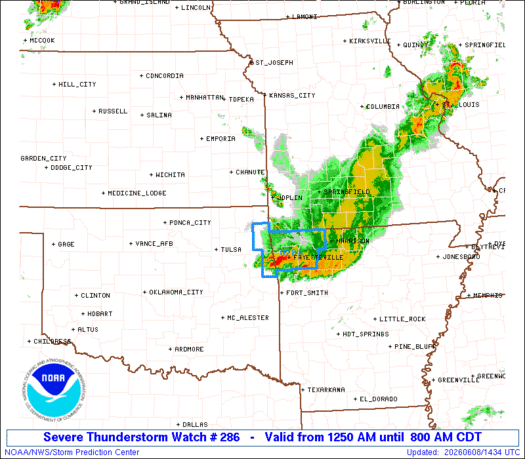
The severe thunderstorm watch area is approximately along and 55
statute miles north and south of a line from 35 miles north of Tulsa
OK to 20 miles north northeast of Harrison AR. For a complete
depiction of the watch see the associated watch outline update
(WOUS64 KWNS WOU6).
PRECAUTIONARY/PREPAREDNESS ACTIONS...
REMEMBER...A Severe Thunderstorm Watch means conditions are
favorable for severe thunderstorms in and close to the watch area.
Persons in these areas should be on the lookout for threatening
weather conditions and listen for later statements and possible
warnings. Severe thunderstorms can and occasionally do produce
tornadoes.
&&
AVIATION...A few severe thunderstorms with hail surface and aloft to
1.5 inches. Extreme turbulence and surface wind gusts to 55 knots. A
few cumulonimbi with maximum tops to 500. Mean storm motion vector
27025.
...Hart

   SEL6

   URGENT - IMMEDIATE BROADCAST REQUESTED
   Severe Thunderstorm Watch Number 286
   NWS Storm Prediction Center Norman OK
   1250 AM CDT Mon Jun 8 2026

   The NWS Storm Prediction Center has issued a

   * Severe Thunderstorm Watch for portions of
     Northwest Arkansas
     Southeast Kansas
     Southwest Missouri
     Northeast Oklahoma

   * Effective this Monday morning from 1250 AM until 800 AM CDT.

   * Primary threats include...
     Scattered damaging wind gusts to 65 mph possible
     A tornado or two possible

   SUMMARY...Thunderstorms will continue to increase in coverage and
   intensity through the overnight hours, with occasionally severe
   storms possible.  Locally damaging winds are the main concern, but
   hail and perhaps a tornado or two are also possible.

   The severe thunderstorm watch area is approximately along and 55
   statute miles north and south of a line from 35 miles north of Tulsa
   OK to 20 miles north northeast of Harrison AR. For a complete
   depiction of the watch see the associated watch outline update
   (WOUS64 KWNS WOU6).

   PRECAUTIONARY/PREPAREDNESS ACTIONS...

   REMEMBER...A Severe Thunderstorm Watch means conditions are
   favorable for severe thunderstorms in and close to the watch area.
   Persons in these areas should be on the lookout for threatening
   weather conditions and listen for later statements and possible
   warnings. Severe thunderstorms can and occasionally do produce
   tornadoes.

   &&

   AVIATION...A few severe thunderstorms with hail surface and aloft to
   1.5 inches. Extreme turbulence and surface wind gusts to 55 knots. A
   few cumulonimbi with maximum tops to 500. Mean storm motion vector
   27025.

   ...Hart

Note:
The Aviation Watch (SAW) product is an approximation to the watch area.
The actual watch is depicted by the shaded areas.
   SAW6
   WW 286 SEVERE TSTM AR KS MO OK 080550Z - 081300Z
   AXIS..55 STATUTE MILES NORTH AND SOUTH OF LINE..
   35N TUL/TULSA OK/ - 20NNE HRO/HARRISON AR/
   ..AVIATION COORDS.. 50NM N/S /31N TUL - 52SSE SGF/
   HAIL SURFACE AND ALOFT..1.5 INCHES. WIND GUSTS..55 KNOTS.
   MAX TOPS TO 500. MEAN STORM MOTION VECTOR 27025.

   LAT...LON 37509588 37339301 35749301 35919588

   THIS IS AN APPROXIMATION TO THE WATCH AREA.  FOR A
   COMPLETE DEPICTION OF THE WATCH SEE WOUS64 KWNS
   FOR WOU6.
Watch 286 Status Report Messages:
STATUS REPORT #3 ON WW 286

VALID 081135Z - 081240Z

SEVERE WEATHER THREAT CONTINUES RIGHT OF A LINE FROM 40 N JLN TO
JLN TO 10 ESE JLN TO 10 ESE JLN TO 15 NW UMN TO 10 NNE UMN TO 45
E SGF.

..WENDT..06/08/26

ATTN...WFO...TSA...SGF...

&&

STATUS REPORT FOR WS 286

SEVERE WEATHER THREAT CONTINUES FOR THE FOLLOWING AREAS

ARC007-015-087-143-081240-

AR
.    ARKANSAS COUNTIES INCLUDED ARE

BENTON		     CARROLL		 MADISON
WASHINGTON
$$


KSC021-037-081240-

KS
.    KANSAS COUNTIES INCLUDED ARE

CHEROKEE	     CRAWFORD
$$


MOC009-043-119-145-209-213-081240-

MO
.    MISSOURI COUNTIES INCLUDED ARE

BARRY		     CHRISTIAN		 MCDONALD
NEWTON		     STONE		 TANEY
$$


OKC001-021-035-041-097-105-115-131-147-081240-

OK
.    OKLAHOMA COUNTIES INCLUDED ARE

ADAIR		     CHEROKEE		 CRAIG
DELAWARE	     MAYES		 NOWATA
OTTAWA		     ROGERS		 WASHINGTON
$$


THE WATCH STATUS MESSAGE IS FOR GUIDANCE PURPOSES ONLY.  PLEASE
REFER TO WATCH COUNTY NOTIFICATION STATEMENTS FOR OFFICIAL
INFORMATION ON COUNTIES...INDEPENDENT CITIES AND MARINE ZONES
CLEARED FROM SEVERE THUNDERSTORM AND TORNADO WATCHES.
$$

STATUS REPORT #2 ON WW 286

VALID 080950Z - 081040Z

THE SEVERE WEATHER THREAT CONTINUES ACROSS THE ENTIRE WATCH AREA.

FOR ADDITIONAL INFORMATION SEE MESOSCALE DISCUSSION 1024

..WENDT..06/08/26

ATTN...WFO...TSA...SGF...

&&

STATUS REPORT FOR WS 286

SEVERE WEATHER THREAT CONTINUES FOR THE FOLLOWING AREAS

ARC007-015-087-143-081040-

AR
.    ARKANSAS COUNTIES INCLUDED ARE

BENTON		     CARROLL		 MADISON
WASHINGTON
$$


KSC021-037-081040-

KS
.    KANSAS COUNTIES INCLUDED ARE

CHEROKEE	     CRAWFORD
$$


MOC009-011-043-057-077-097-109-119-145-209-213-081040-

MO
.    MISSOURI COUNTIES INCLUDED ARE

BARRY		     BARTON		 CHRISTIAN
DADE		     GREENE		 JASPER
LAWRENCE	     MCDONALD		 NEWTON
STONE		     TANEY
$$


OKC001-021-035-041-097-105-115-131-147-081040-

OK
.    OKLAHOMA COUNTIES INCLUDED ARE

ADAIR		     CHEROKEE		 CRAIG
DELAWARE	     MAYES		 NOWATA
OTTAWA		     ROGERS		 WASHINGTON
$$


THE WATCH STATUS MESSAGE IS FOR GUIDANCE PURPOSES ONLY.  PLEASE
REFER TO WATCH COUNTY NOTIFICATION STATEMENTS FOR OFFICIAL
INFORMATION ON COUNTIES...INDEPENDENT CITIES AND MARINE ZONES
CLEARED FROM SEVERE THUNDERSTORM AND TORNADO WATCHES.
$$

STATUS REPORT #1 ON WW 286

VALID 080740Z - 080840Z

THE SEVERE WEATHER THREAT CONTINUES ACROSS THE ENTIRE WATCH AREA.

..WENDT..06/08/26

ATTN...WFO...TSA...SGF...

&&

STATUS REPORT FOR WS 286

SEVERE WEATHER THREAT CONTINUES FOR THE FOLLOWING AREAS

ARC007-015-087-143-080840-

AR
.    ARKANSAS COUNTIES INCLUDED ARE

BENTON		     CARROLL		 MADISON
WASHINGTON
$$


KSC021-037-080840-

KS
.    KANSAS COUNTIES INCLUDED ARE

CHEROKEE	     CRAWFORD
$$


MOC009-011-043-057-077-097-109-119-145-209-213-080840-

MO
.    MISSOURI COUNTIES INCLUDED ARE

BARRY		     BARTON		 CHRISTIAN
DADE		     GREENE		 JASPER
LAWRENCE	     MCDONALD		 NEWTON
STONE		     TANEY
$$


OKC001-021-035-041-097-105-115-131-147-080840-

OK
.    OKLAHOMA COUNTIES INCLUDED ARE

ADAIR		     CHEROKEE		 CRAIG
DELAWARE	     MAYES		 NOWATA
OTTAWA		     ROGERS		 WASHINGTON
$$


THE WATCH STATUS MESSAGE IS FOR GUIDANCE PURPOSES ONLY.  PLEASE
REFER TO WATCH COUNTY NOTIFICATION STATEMENTS FOR OFFICIAL
INFORMATION ON COUNTIES...INDEPENDENT CITIES AND MARINE ZONES
CLEARED FROM SEVERE THUNDERSTORM AND TORNADO WATCHES.
$$

Note:
Click for Complete Product Text.
Tornadoes
| Probability of 2 or more tornadoes |
Low (20%) |
| Probability of 1 or more strong (EF2-EF5) tornadoes |
Low (5%) |
Wind
| Probability of 10 or more severe wind events |
Mod (40%) |
| Probability of 1 or more wind events > 65 knots |
Low (20%) |
Hail
| Probability of 10 or more severe hail events |
Low (10%) |
| Probability of 1 or more hailstones > 2 inches |
Low ( |
Combined Severe Hail/Wind
| Probability of 6 or more combined severe hail/wind events |
Mod (60%) |
For each watch, probabilities for particular events inside the watch
(listed above in each table) are determined by the issuing forecaster.
The “Low” category contains probability values ranging from less than 2%
to 20% (EF2-EF5 tornadoes), less than 5% to 20% (all other probabilities),
“Moderate” from 30% to 60%, and “High” from 70% to greater than 95%.
High values are bolded and lighter in color to provide awareness of
an increased threat for a particular event.