Note:
The expiration time in the watch graphic is amended if the watch is
replaced, cancelled or extended.
Note: Click for Watch Status Reports.
SEL3
URGENT - IMMEDIATE BROADCAST REQUESTED
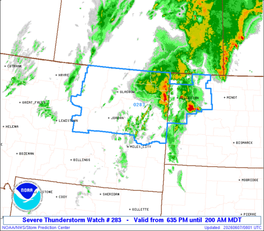
Severe Thunderstorm Watch Number 283
NWS Storm Prediction Center Norman OK
635 PM MDT Sat Jun 6 2026
The NWS Storm Prediction Center has issued a
* Severe Thunderstorm Watch for portions of
Eastern Montana
Western North Dakota
* Effective this Saturday night and Sunday morning from 635 PM
until 200 AM MDT.
* Primary threats include...
Scattered damaging winds and isolated significant gusts to 75
mph possible
Scattered large hail and isolated very large hail events to 2
inches in diameter possible
SUMMARY...A mix of high-based supercells and multicells should pose
a threat for large hail up to 1-2 inches in diameter and
severe/damaging winds around 60-75 mph this evening and through the
early overnight hours as this activity moves northeastward.
The severe thunderstorm watch area is approximately along and 125
statute miles east and west of a line from 25 miles south of Miles
City MT to 70 miles north northeast of Wolf Point MT. For a complete
depiction of the watch see the associated watch outline update
(WOUS64 KWNS WOU3).
PRECAUTIONARY/PREPAREDNESS ACTIONS...
REMEMBER...A Severe Thunderstorm Watch means conditions are
favorable for severe thunderstorms in and close to the watch area.
Persons in these areas should be on the lookout for threatening
weather conditions and listen for later statements and possible
warnings. Severe thunderstorms can and occasionally do produce
tornadoes.
&&
OTHER WATCH INFORMATION...CONTINUE...WW 279...WW 281...WW 282...
AVIATION...A few severe thunderstorms with hail surface and aloft to
2 inches. Extreme turbulence and surface wind gusts to 65 knots. A
few cumulonimbi with maximum tops to 500. Mean storm motion vector
21040.
...Gleason

Note:
The Aviation Watch (SAW) product is an approximation to the watch area.
The actual watch is depicted by the shaded areas.
   SAW3
   WW 283 SEVERE TSTM MT ND 070035Z - 070800Z
   AXIS..125 STATUTE MILES EAST AND WEST OF LINE..
   25S MLS/MILES CITY MT/ - 70NNE OLF/WOLF POINT MT/
   ..AVIATION COORDS.. 110NM E/W /19S MLS - 74NW ISN/
   HAIL SURFACE AND ALOFT..2 INCHES. WIND GUSTS..65 KNOTS.
   MAX TOPS TO 500. MEAN STORM MOTION VECTOR 21040.

   LAT...LON 46040849 49000775 49000223 46040327

   THIS IS AN APPROXIMATION TO THE WATCH AREA.  FOR A
   COMPLETE DEPICTION OF THE WATCH SEE WOUS64 KWNS
   FOR WOU3.
Watch 283 Status Report Messages:
STATUS REPORT #3 ON WW 283

VALID 070540Z - 070640Z

SEVERE WEATHER THREAT CONTINUES RIGHT OF A LINE FROM 60 WSW MLS
TO 40 S GGW TO 20 N OLF TO 90 NNE OLF.

..WENDT..06/07/26

ATTN...WFO...BYZ...GGW...BIS...

&&

STATUS REPORT FOR WS 283

SEVERE WEATHER THREAT CONTINUES FOR THE FOLLOWING AREAS

MTC017-019-021-025-033-055-079-083-085-087-091-109-070640-

MT
.    MONTANA COUNTIES INCLUDED ARE

CUSTER		     DANIELS		 DAWSON
FALLON		     GARFIELD		 MCCONE
PRAIRIE 	     RICHLAND		 ROOSEVELT
ROSEBUD 	     SHERIDAN		 WIBAUX
$$


NDC007-011-013-023-033-053-061-087-105-070640-

ND
.    NORTH DAKOTA COUNTIES INCLUDED ARE

BILLINGS	     BOWMAN		 BURKE
DIVIDE		     GOLDEN VALLEY	 MCKENZIE
MOUNTRAIL	     SLOPE		 WILLIAMS
$$


THE WATCH STATUS MESSAGE IS FOR GUIDANCE PURPOSES ONLY.  PLEASE
REFER TO WATCH COUNTY NOTIFICATION STATEMENTS FOR OFFICIAL
INFORMATION ON COUNTIES...INDEPENDENT CITIES AND MARINE ZONES
CLEARED FROM SEVERE THUNDERSTORM AND TORNADO WATCHES.
$$

STATUS REPORT #2 ON WW 283

VALID 070430Z - 070540Z

SEVERE WEATHER THREAT CONTINUES RIGHT OF A LINE FROM 60 WSW MLS
TO 80 NNW GGW.

..LYONS..06/07/26

ATTN...WFO...BYZ...GGW...BIS...

&&

STATUS REPORT FOR WS 283

SEVERE WEATHER THREAT CONTINUES FOR THE FOLLOWING AREAS

MTC017-019-021-025-033-055-079-083-085-087-091-105-109-070540-

MT
.    MONTANA COUNTIES INCLUDED ARE

CUSTER		     DANIELS		 DAWSON
FALLON		     GARFIELD		 MCCONE
PRAIRIE 	     RICHLAND		 ROOSEVELT
ROSEBUD 	     SHERIDAN		 VALLEY
WIBAUX
$$


NDC007-011-013-023-033-053-061-087-105-070540-

ND
.    NORTH DAKOTA COUNTIES INCLUDED ARE

BILLINGS	     BOWMAN		 BURKE
DIVIDE		     GOLDEN VALLEY	 MCKENZIE
MOUNTRAIL	     SLOPE		 WILLIAMS
$$


THE WATCH STATUS MESSAGE IS FOR GUIDANCE PURPOSES ONLY.  PLEASE
REFER TO WATCH COUNTY NOTIFICATION STATEMENTS FOR OFFICIAL
INFORMATION ON COUNTIES...INDEPENDENT CITIES AND MARINE ZONES
CLEARED FROM SEVERE THUNDERSTORM AND TORNADO WATCHES.
$$

STATUS REPORT #1 ON WW 283

VALID 070120Z - 070240Z

THE SEVERE WEATHER THREAT CONTINUES ACROSS THE ENTIRE WATCH AREA.

..SUPINIE..06/07/26

ATTN...WFO...BYZ...GGW...BIS...

&&

STATUS REPORT FOR WS 283

SEVERE WEATHER THREAT CONTINUES FOR THE FOLLOWING AREAS

MTC017-019-021-025-033-055-069-071-079-083-085-087-091-105-109-
070240-

MT
.    MONTANA COUNTIES INCLUDED ARE

CUSTER		     DANIELS		 DAWSON
FALLON		     GARFIELD		 MCCONE
PETROLEUM	     PHILLIPS		 PRAIRIE
RICHLAND	     ROOSEVELT		 ROSEBUD
SHERIDAN	     VALLEY		 WIBAUX
$$


NDC007-011-013-023-033-053-061-087-105-070240-

ND
.    NORTH DAKOTA COUNTIES INCLUDED ARE

BILLINGS	     BOWMAN		 BURKE
DIVIDE		     GOLDEN VALLEY	 MCKENZIE
MOUNTRAIL	     SLOPE		 WILLIAMS
$$


THE WATCH STATUS MESSAGE IS FOR GUIDANCE PURPOSES ONLY.  PLEASE
REFER TO WATCH COUNTY NOTIFICATION STATEMENTS FOR OFFICIAL
INFORMATION ON COUNTIES...INDEPENDENT CITIES AND MARINE ZONES
CLEARED FROM SEVERE THUNDERSTORM AND TORNADO WATCHES.
$$

Note:
Click for Complete Product Text.
Tornadoes
| Probability of 2 or more tornadoes |
Low (10%) |
| Probability of 1 or more strong (EF2-EF5) tornadoes |
Low ( |
Wind
| Probability of 10 or more severe wind events |
Mod (50%) |
| Probability of 1 or more wind events > 65 knots |
Mod (40%) |
Hail
| Probability of 10 or more severe hail events |
Mod (40%) |
| Probability of 1 or more hailstones > 2 inches |
Mod (30%) |
Combined Severe Hail/Wind
| Probability of 6 or more combined severe hail/wind events |
High (80%) |
For each watch, probabilities for particular events inside the watch
(listed above in each table) are determined by the issuing forecaster.
The “Low” category contains probability values ranging from less than 2%
to 20% (EF2-EF5 tornadoes), less than 5% to 20% (all other probabilities),
“Moderate” from 30% to 60%, and “High” from 70% to greater than 95%.
High values are bolded and lighter in color to provide awareness of
an increased threat for a particular event.