Note:
The expiration time in the watch graphic is amended if the watch is
replaced, cancelled or extended.
Note: Click for Watch Status Reports.
SEL6
URGENT - IMMEDIATE BROADCAST REQUESTED
Severe Thunderstorm Watch Number 276
NWS Storm Prediction Center Norman OK
950 PM CDT Fri Jun 5 2026
The NWS Storm Prediction Center has issued a
* Severe Thunderstorm Watch for portions of
Southern and Southeastern Iowa
* Effective this Friday night and Saturday morning from 950 PM
until 300 AM CDT.
* Primary threats include...
Scattered large hail and isolated very large hail events to 2
inches in diameter possible
Scattered damaging wind gusts to 70 mph possible
A tornado or two possible
SUMMARY...Supercells should continue to pose a threat for large to
very large hail this evening (up to 2 inches in diameter possible).
A tornado or two may also occur with this activity. A loosely
organized thunderstorm cluster may eventually move across southern
IA overnight and pose some risk for severe/damaging winds.
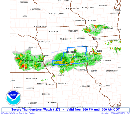
The severe thunderstorm watch area is approximately along and 40
statute miles north and south of a line from 60 miles west northwest
of Lamoni IA to 55 miles east northeast of Ottumwa IA. For a
complete depiction of the watch see the associated watch outline
update (WOUS64 KWNS WOU6).
PRECAUTIONARY/PREPAREDNESS ACTIONS...
REMEMBER...A Severe Thunderstorm Watch means conditions are
favorable for severe thunderstorms in and close to the watch area.
Persons in these areas should be on the lookout for threatening
weather conditions and listen for later statements and possible
warnings. Severe thunderstorms can and occasionally do produce
tornadoes.
&&
OTHER WATCH INFORMATION...CONTINUE...WW 274...WW 275...
AVIATION...A few severe thunderstorms with hail surface and aloft to
2 inches. Extreme turbulence and surface wind gusts to 60 knots. A
few cumulonimbi with maximum tops to 550. Mean storm motion vector
27025.
...Gleason

Note:
The Aviation Watch (SAW) product is an approximation to the watch area.
The actual watch is depicted by the shaded areas.
   SAW6
   WW 276 SEVERE TSTM IA 060250Z - 060800Z
   AXIS..40 STATUTE MILES NORTH AND SOUTH OF LINE..
   60WNW LWD/LAMONI IA/ - 55ENE OTM/OTTUMWA IA/
   ..AVIATION COORDS.. 35NM N/S /37ESE OVR - 10SE IOW/
   HAIL SURFACE AND ALOFT..2 INCHES. WIND GUSTS..60 KNOTS.
   MAX TOPS TO 550. MEAN STORM MOTION VECTOR 27025.

   LAT...LON 41529499 41989147 40829147 40369499

   THIS IS AN APPROXIMATION TO THE WATCH AREA.  FOR A
   COMPLETE DEPICTION OF THE WATCH SEE WOUS64 KWNS
   FOR WOU6.
Watch 276 Status Report Messages:
STATUS REPORT #2 ON WW 276

VALID 060635Z - 060740Z

SEVERE WEATHER THREAT CONTINUES RIGHT OF A LINE FROM 40 W LWD TO
25 N LWD TO 30 NNE LWD TO 10 WSW OXV TO 30 N BRL.

..WENDT..06/06/26

ATTN...WFO...DMX...DVN...

&&

STATUS REPORT FOR WS 276

SEVERE WEATHER THREAT CONTINUES FOR THE FOLLOWING AREAS

IAC007-051-053-087-101-117-135-159-177-179-185-060740-

IA
.    IOWA COUNTIES INCLUDED ARE

APPANOOSE	     DAVIS		 DECATUR
HENRY		     JEFFERSON		 LUCAS
MONROE		     RINGGOLD		 VAN BUREN
WAPELLO 	     WAYNE
$$


THE WATCH STATUS MESSAGE IS FOR GUIDANCE PURPOSES ONLY.  PLEASE
REFER TO WATCH COUNTY NOTIFICATION STATEMENTS FOR OFFICIAL
INFORMATION ON COUNTIES...INDEPENDENT CITIES AND MARINE ZONES
CLEARED FROM SEVERE THUNDERSTORM AND TORNADO WATCHES.
$$

STATUS REPORT #1 ON WW 276

VALID 060345Z - 060440Z

THE SEVERE WEATHER THREAT CONTINUES ACROSS THE ENTIRE WATCH AREA.

..LYONS..06/06/26

ATTN...WFO...DMX...DVN...

&&

STATUS REPORT FOR WS 276

SEVERE WEATHER THREAT CONTINUES FOR THE FOLLOWING AREAS

IAC001-003-007-029-039-051-053-087-095-099-101-103-107-117-121-
123-125-135-157-159-173-175-177-179-181-183-185-060440-

IA
.    IOWA COUNTIES INCLUDED ARE

ADAIR		     ADAMS		 APPANOOSE
CASS		     CLARKE		 DAVIS
DECATUR 	     HENRY		 IOWA
JASPER		     JEFFERSON		 JOHNSON
KEOKUK		     LUCAS		 MADISON
MAHASKA 	     MARION		 MONROE
POWESHIEK	     RINGGOLD		 TAYLOR
UNION		     VAN BUREN		 WAPELLO
WARREN		     WASHINGTON 	 WAYNE
$$


THE WATCH STATUS MESSAGE IS FOR GUIDANCE PURPOSES ONLY.  PLEASE
REFER TO WATCH COUNTY NOTIFICATION STATEMENTS FOR OFFICIAL
INFORMATION ON COUNTIES...INDEPENDENT CITIES AND MARINE ZONES
CLEARED FROM SEVERE THUNDERSTORM AND TORNADO WATCHES.
$$

Note:
Click for Complete Product Text.
Tornadoes
| Probability of 2 or more tornadoes |
Low (20%) |
| Probability of 1 or more strong (EF2-EF5) tornadoes |
Low (10%) |
Wind
| Probability of 10 or more severe wind events |
Mod (40%) |
| Probability of 1 or more wind events > 65 knots |
Low (10%) |
Hail
| Probability of 10 or more severe hail events |
Mod (40%) |
| Probability of 1 or more hailstones > 2 inches |
Mod (30%) |
Combined Severe Hail/Wind
| Probability of 6 or more combined severe hail/wind events |
High (70%) |
For each watch, probabilities for particular events inside the watch
(listed above in each table) are determined by the issuing forecaster.
The “Low” category contains probability values ranging from less than 2%
to 20% (EF2-EF5 tornadoes), less than 5% to 20% (all other probabilities),
“Moderate” from 30% to 60%, and “High” from 70% to greater than 95%.
High values are bolded and lighter in color to provide awareness of
an increased threat for a particular event.