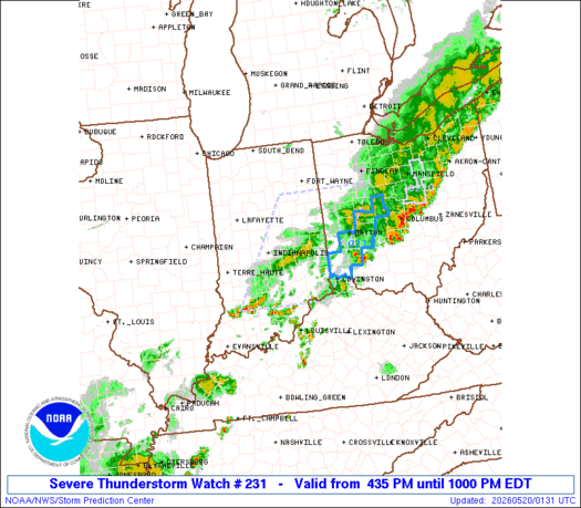
Note:
The expiration time in the watch graphic is amended if the watch is
replaced, cancelled or extended.
Note: Click for Watch Status Reports.
   SEL1

   URGENT - IMMEDIATE BROADCAST REQUESTED
   Severe Thunderstorm Watch Number 231
   NWS Storm Prediction Center Norman OK
   435 PM EDT Tue May 19 2026

   The NWS Storm Prediction Center has issued a

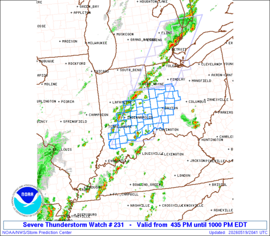
   * Severe Thunderstorm Watch for portions of
     Central Indiana
     Western Ohio

   * Effective this Tuesday afternoon and evening from 435 PM until
     1000 PM EDT.

   * Primary threats include...
     Scattered damaging wind gusts to 70 mph likely
     Isolated large hail events to 1 inch in diameter possible

   SUMMARY...Thunderstorms will intensify over central Indiana and
   spread eastward through the afternoon, posing a risk of locally
   damaging wind gusts.

   The severe thunderstorm watch area is approximately along and 60
   statute miles east and west of a line from 55 miles northeast of
   Muncie IN to 45 miles southeast of Bloomington IN. For a complete
   depiction of the watch see the associated watch outline update
   (WOUS64 KWNS WOU1).

   PRECAUTIONARY/PREPAREDNESS ACTIONS...

   REMEMBER...A Severe Thunderstorm Watch means conditions are
   favorable for severe thunderstorms in and close to the watch area.
   Persons in these areas should be on the lookout for threatening
   weather conditions and listen for later statements and possible
   warnings. Severe thunderstorms can and occasionally do produce
   tornadoes.

   &&

   OTHER WATCH INFORMATION...CONTINUE...WW 230...

   AVIATION...A few severe thunderstorms with hail surface and aloft to
   1 inch. Extreme turbulence and surface wind gusts to 60 knots. A few
   cumulonimbi with maximum tops to 500. Mean storm motion vector
   24030.

   ...Hart
   SEL1

   URGENT - IMMEDIATE BROADCAST REQUESTED
   Severe Thunderstorm Watch Number 231
   NWS Storm Prediction Center Norman OK
   435 PM EDT Tue May 19 2026

   The NWS Storm Prediction Center has issued a

   * Severe Thunderstorm Watch for portions of
     Central Indiana
     Western Ohio

   * Effective this Tuesday afternoon and evening from 435 PM until
     1000 PM EDT.

   * Primary threats include...
     Scattered damaging wind gusts to 70 mph likely
     Isolated large hail events to 1 inch in diameter possible

   SUMMARY...Thunderstorms will intensify over central Indiana and
   spread eastward through the afternoon, posing a risk of locally
   damaging wind gusts.

   The severe thunderstorm watch area is approximately along and 60
   statute miles east and west of a line from 55 miles northeast of
   Muncie IN to 45 miles southeast of Bloomington IN. For a complete
   depiction of the watch see the associated watch outline update
   (WOUS64 KWNS WOU1).

   PRECAUTIONARY/PREPAREDNESS ACTIONS...

   REMEMBER...A Severe Thunderstorm Watch means conditions are
   favorable for severe thunderstorms in and close to the watch area.
   Persons in these areas should be on the lookout for threatening
   weather conditions and listen for later statements and possible
   warnings. Severe thunderstorms can and occasionally do produce
   tornadoes.

   &&

   OTHER WATCH INFORMATION...CONTINUE...WW 230...

   AVIATION...A few severe thunderstorms with hail surface and aloft to
   1 inch. Extreme turbulence and surface wind gusts to 60 knots. A few
   cumulonimbi with maximum tops to 500. Mean storm motion vector
   24030.

   ...Hart
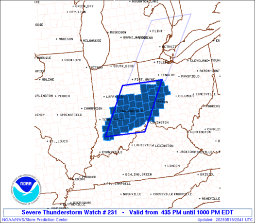
Note:
The Aviation Watch (SAW) product is an approximation to the watch area.
The actual watch is depicted by the shaded areas.
   SAW1
   WW 231 SEVERE TSTM IN OH 192035Z - 200200Z
   AXIS..60 STATUTE MILES EAST AND WEST OF LINE..
   55NE MIE/MUNCIE IN/ - 45SE BMG/BLOOMINGTON IN/
   ..AVIATION COORDS.. 50NM E/W /26ESE FWA - 41NNW IIU/
   HAIL SURFACE AND ALOFT..1 INCH. WIND GUSTS..60 KNOTS.
   MAX TOPS TO 500. MEAN STORM MOTION VECTOR 24030.

   LAT...LON 40808351 38688492 38688714 40808580

   THIS IS AN APPROXIMATION TO THE WATCH AREA.  FOR A
   COMPLETE DEPICTION OF THE WATCH SEE WOUS64 KWNS
   FOR WOU1.
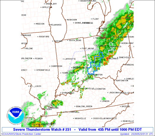
Watch 231 Status Report Messages:
STATUS REPORT #2 ON WW 231

VALID 200000Z - 200140Z

SEVERE WEATHER THREAT CONTINUES RIGHT OF A LINE FROM 15 W BMG TO
40 WSW DAY TO 40 NE DAY.

FOR ADDITIONAL INFORMATION SEE MESOSCALE DISCUSSION 797

..SQUITIERI..05/19/26

ATTN...WFO...IND...ILN...

&&

STATUS REPORT FOR WS 231

SEVERE WEATHER THREAT CONTINUES FOR THE FOLLOWING AREAS

INC005-013-027-029-031-047-055-071-079-093-101-105-137-200140-

IN
.    INDIANA COUNTIES INCLUDED ARE

BARTHOLOMEW     BROWN DAVIESS
DEARBORN     DECATUR FRANKLIN
GREENE     JACKSON JENNINGS
LAWRENCE     MARTIN MONROE
RIPLEY
$$


OHC017-021-023-057-061-109-113-135-159-165-200140-

OH
.    OHIO COUNTIES INCLUDED ARE

BUTLER     CHAMPAIGN CLARK
GREENE     HAMILTON MIAMI
MONTGOMERY     PREBLE UNION
WARREN
$$


THE WATCH STATUS MESSAGE IS FOR GUIDANCE PURPOSES ONLY.  PLEASE
REFER TO WATCH COUNTY NOTIFICATION STATEMENTS FOR OFFICIAL
INFORMATION ON COUNTIES...INDEPENDENT CITIES AND MARINE ZONES
CLEARED FROM SEVERE THUNDERSTORM AND TORNADO WATCHES.
$$

STATUS REPORT #1 ON WW 231

VALID 192325Z - 200040Z

SEVERE WEATHER THREAT CONTINUES RIGHT OF A LINE FROM 20 NNW IND
TO 25 NW DAY TO 10 SE FDY.

..SQUITIERI..05/19/26

ATTN...WFO...IND...ILN...

&&

STATUS REPORT FOR WS 231

SEVERE WEATHER THREAT CONTINUES FOR THE FOLLOWING AREAS

INC005-013-027-029-031-041-047-055-071-079-081-093-101-105-137-
139-145-161-177-200040-

IN
.    INDIANA COUNTIES INCLUDED ARE

BARTHOLOMEW     BROWN DAVIESS
DEARBORN     DECATUR FAYETTE
FRANKLIN     GREENE JACKSON
JENNINGS     JOHNSON LAWRENCE
MARTIN     MONROE RIPLEY
RUSH     SHELBY UNION
WAYNE
$$


OHC017-021-023-057-061-065-091-109-113-135-159-165-200040-

OH
.    OHIO COUNTIES INCLUDED ARE

BUTLER     CHAMPAIGN CLARK
GREENE     HAMILTON HARDIN
LOGAN     MIAMI MONTGOMERY
PREBLE     UNION WARREN
$$


THE WATCH STATUS MESSAGE IS FOR GUIDANCE PURPOSES ONLY.  PLEASE
REFER TO WATCH COUNTY NOTIFICATION STATEMENTS FOR OFFICIAL
INFORMATION ON COUNTIES...INDEPENDENT CITIES AND MARINE ZONES
CLEARED FROM SEVERE THUNDERSTORM AND TORNADO WATCHES.
$$
Note:
Click for Complete Product Text.
Tornadoes
| Probability of 2 or more tornadoes | Low (
|
| Probability of 1 or more strong (EF2-EF5) tornadoes | Low (
|
Wind
| Probability of 10 or more severe wind events | Mod (60%) |
| Probability of 1 or more wind events > 65 knots | Low (20%) |
Hail
| Probability of 10 or more severe hail events | Mod (30%) |
| Probability of 1 or more hailstones > 2 inches | Low (20%) |
Combined Severe Hail/Wind
| Probability of 6 or more combined severe hail/wind events | High (80%) |
For each watch, probabilities for particular events inside the watch
(listed above in each table) are determined by the issuing forecaster.
The “Low” category contains probability values ranging from less than 2%
to 20% (EF2-EF5 tornadoes), less than 5% to 20% (all other probabilities),
“Moderate” from 30% to 60%, and “High” from 70% to greater than 95%.
High values are bolded and lighter in color to provide awareness of
an increased threat for a particular event.
Source link