Note:
The expiration time in the watch graphic is amended if the watch is
replaced, cancelled or extended.
Note: Click for Watch Status Reports.
SEL8
URGENT - IMMEDIATE BROADCAST REQUESTED
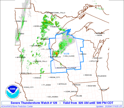
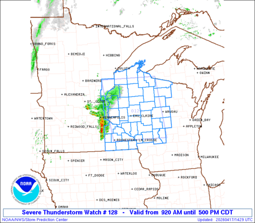
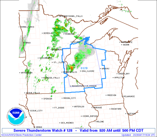
Severe Thunderstorm Watch Number 128
NWS Storm Prediction Center Norman OK
920 AM CDT Fri Apr 17 2026
The NWS Storm Prediction Center has issued a
* Severe Thunderstorm Watch for portions of
East-Central and Far Southeast Minnesota
Northwest and North-Central Wisconsin
* Effective this Friday morning and afternoon from 920 AM until
500 PM CDT.
* Primary threats include...
Scattered large hail and isolated very large hail events to 2
inches in diameter possible
Isolated damaging wind gusts to 70 mph possible
SUMMARY...Ongoing line of thunderstorms over southeast MN is
forecast to continue northeastward. The overall environment ahead of
this line is expected to become more supportive of strong to severe
storms with time. Additional thunderstorm development is anticipated
as well. Large hail is the primary severe risk, although isolated
strong gusts are possible as well.
The severe thunderstorm watch area is approximately along and 75
statute miles east and west of a line from 105 miles north of Eau
Claire WI to 10 miles east of La Crosse WI. For a complete depiction
of the watch see the associated watch outline update (WOUS64 KWNS
WOU8).
PRECAUTIONARY/PREPAREDNESS ACTIONS...
REMEMBER...A Severe Thunderstorm Watch means conditions are
favorable for severe thunderstorms in and close to the watch area.
Persons in these areas should be on the lookout for threatening
weather conditions and listen for later statements and possible
warnings. Severe thunderstorms can and occasionally do produce
tornadoes.
&&
AVIATION...A few severe thunderstorms with hail surface and aloft to
2 inches. Extreme turbulence and surface wind gusts to 60 knots. A
few cumulonimbi with maximum tops to 500. Mean storm motion vector
24030.
...Mosier
   SEL8

   URGENT - IMMEDIATE BROADCAST REQUESTED
   Severe Thunderstorm Watch Number 128
   NWS Storm Prediction Center Norman OK
   920 AM CDT Fri Apr 17 2026

   The NWS Storm Prediction Center has issued a

   * Severe Thunderstorm Watch for portions of
     East-Central and Far Southeast Minnesota
     Northwest and North-Central Wisconsin

   * Effective this Friday morning and afternoon from 920 AM until
     500 PM CDT.

   * Primary threats include...
     Scattered large hail and isolated very large hail events to 2
       inches in diameter possible
     Isolated damaging wind gusts to 70 mph possible

   SUMMARY...Ongoing line of thunderstorms over southeast MN is
   forecast to continue northeastward. The overall environment ahead of
   this line is expected to become more supportive of strong to severe
   storms with time. Additional thunderstorm development is anticipated
   as well. Large hail is the primary severe risk, although isolated
   strong gusts are possible as well.

   The severe thunderstorm watch area is approximately along and 75
   statute miles east and west of a line from 105 miles north of Eau
   Claire WI to 10 miles east of La Crosse WI. For a complete depiction
   of the watch see the associated watch outline update (WOUS64 KWNS
   WOU8).

   PRECAUTIONARY/PREPAREDNESS ACTIONS...

   REMEMBER...A Severe Thunderstorm Watch means conditions are
   favorable for severe thunderstorms in and close to the watch area.
   Persons in these areas should be on the lookout for threatening
   weather conditions and listen for later statements and possible
   warnings. Severe thunderstorms can and occasionally do produce
   tornadoes.

   &&

   AVIATION...A few severe thunderstorms with hail surface and aloft to
   2 inches. Extreme turbulence and surface wind gusts to 60 knots. A
   few cumulonimbi with maximum tops to 500. Mean storm motion vector
   24030.

   ...Mosier
Note:
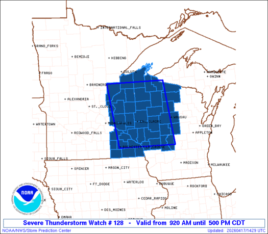
The Aviation Watch (SAW) product is an approximation to the watch area.
The actual watch is depicted by the shaded areas.
   SAW8
   WW 128 SEVERE TSTM MN WI 171420Z - 172200Z
   AXIS..75 STATUTE MILES EAST AND WEST OF LINE..
   105N EAU/EAU CLAIRE WI/ - 10E LSE/LA CROSSE WI/
   ..AVIATION COORDS.. 65NM E/W /39SE DLH - 18E ODI/
   HAIL SURFACE AND ALOFT..2 INCHES. WIND GUSTS..60 KNOTS.
   MAX TOPS TO 500. MEAN STORM MOTION VECTOR 24030.

   LAT...LON 46388991 43878954 43879255 46389305

   THIS IS AN APPROXIMATION TO THE WATCH AREA.  FOR A
   COMPLETE DEPICTION OF THE WATCH SEE WOUS64 KWNS
   FOR WOU8.
Watch 128 Status Report Message has not been issued yet.
Note:
Click for Complete Product Text.
Tornadoes
| Probability of 2 or more tornadoes | Low (10%) |
| Probability of 1 or more strong (EF2-EF5) tornadoes | Low (10%) |
Wind
| Probability of 10 or more severe wind events | Mod (30%) |
| Probability of 1 or more wind events > 65 knots | Low (10%) |
Hail
| Probability of 10 or more severe hail events | Mod (50%) |
| Probability of 1 or more hailstones > 2 inches | Mod (30%) |
Combined Severe Hail/Wind
| Probability of 6 or more combined severe hail/wind events | High (70%) |
For each watch, probabilities for particular events inside the watch
(listed above in each table) are determined by the issuing forecaster.
The “Low” category contains probability values ranging from less than 2%
to 20% (EF2-EF5 tornadoes), less than 5% to 20% (all other probabilities),
“Moderate” from 30% to 60%, and “High” from 70% to greater than 95%.
High values are bolded and lighter in color to provide awareness of
an increased threat for a particular event.
Source link