|
|
| Mesoscale Discussion 985 | |
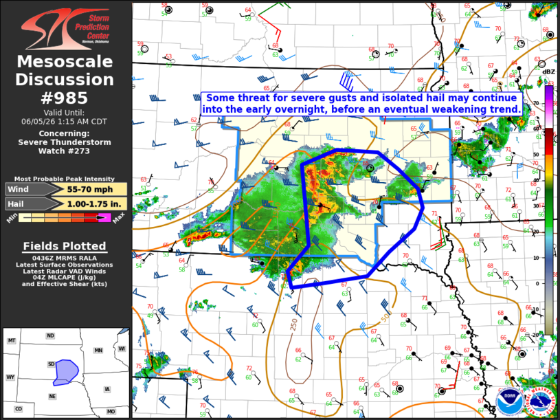 | |
Mesoscale Discussion 0985 NWS Storm Prediction Center Norman OK 1139 PM CDT Thu Jun 04 2026 Areas affected...Parts of south-central/southeast SD into far northern NE Concerning...Severe Thunderstorm Watch 273... Valid 050439Z - 050615Z The severe weather threat for Severe Thunderstorm Watch 273 continues. SUMMARY...Some severe threat may persist into the early overnight hours, though an eventual weakening trend is expected with time. DISCUSSION...A storm cluster has grown in size late this evening from central SD Into far northern NE, along and north of a surface boundary. Measured severe gusts have recently been noted across south-central SD and far northern NE, and some severe-wind threat may continue after Midnight CDT, as this cluster moves eastward across a moderately unstable environment. Stronger embedded updrafts may also be capable of isolated hail. With only modest organization noted with the ongoing cluster, and increasing CINH downstream, an eventual weakening trend is expected overnight. Depending on short-term observational trends, a local expansion of WW 273 may eventually be needed, but longevity of the severe threat appears too limited for new watch issuance. ..Dean/Guyer.. 06/05/2026 ...Please see www.spc.noaa.gov for graphic product... ATTN...WFO...FSD...OAX...ABR...LBF...UNR... LAT...LON 44439972 44669895 44639805 44369759 44059718 43759708 43419726 43059782 42689829 42569920 42499990 42759999 43159954 44439972 MOST PROBABLE PEAK WIND GUST...55-70 MPH MOST PROBABLE PEAK HAIL SIZE...1.00-1.75 IN | |
| Top/All Mesoscale Discussions/Forecast Products/Home | |