|
|
| Mesoscale Discussion 967 | |
| Next MD > | |
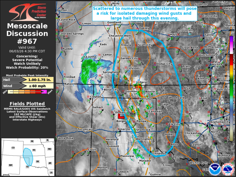 | |
   Mesoscale Discussion 0967
   NWS Storm Prediction Center Norman OK
   0202 PM CDT Wed Jun 03 2026

   Areas affected...portions of the southern/central Great Plains

   Concerning...Severe potential...Watch unlikely

   Valid 031902Z - 032130Z

   Probability of Watch Issuance...20 percent

   SUMMARY...Scattered to numerous strong to occasionally severe
   thunderstorms may bring a risk for isolated damaging wind gusts and
   large hail this afternoon and evening. Watch issuance is unlikely.

   DISCUSSION...Latest surface analysis depicts a surface trough
   extending southward from eastern Colorado/western Kansas into the
   Texas Panhandle, with a weak low analyzed north of Amarillo, TX.
   Visible satellite imagery depicts developing thunderstorms along
   this surface trough and an additional surface confluence zone
   extending southeastward from the Oklahoma Panhandle into western
   Oklahoma downstream of a remnant MCV evident near the NM/TX/OK
   border. Latest objective analysis and the 18z AMA/DDC observed
   soundings suggest that lingering inhibition is eroding amid
   continued diurnal heating, with MLCAPE of 1000-2000 J/kg, which will
   allow for a further increase in thunderstorm coverage through the
   afternoon.

   Modestly enhanced mid-level flow in close proximity to the
   aforementioned MCV (30+ kts at 4-5 km AGL sampled by the AMA VAD
   profile) is contributing to locally enhanced effective shear (25-35+
   kts per latest mesoanalysis). This should support marginal storm
   organization, with multicells and marginal supercell structures
   possible. The main threat with these storms will be damaging
   downburst wind gusts given steep low-level lapse rates. Isolated
   large hail will also be possible with the more robust updrafts,
   particularly across the eastern Oklahoma Panhandle into southwestern
   Kansas where enhanced effective shear downstream of the MCV overlaps
   steeper mid-level lapse rates (around 7 C/km sampled by the 18z DDC
   sounding).

   Watch issuance appears unlikely at this time owing to the
   expectation for the severe threat magnitude to remain largely
   limited, but trends will continue to be monitored.

   ..Chalmers/Mosier.. 06/03/2026

   ...Please see www.spc.noaa.gov for graphic product...

   ATTN...WFO...OUN...DDC...GLD...LUB...AMA...PUB...

   LAT...LON   35640137 36370176 36880202 37140209 37650205 38700176
               39130141 39100069 38669969 37949919 36979882 36089875
               35319894 34559928 34309961 34240005 34430038 34870086
               35640137

   MOST PROBABLE PEAK WIND GUST...UP TO 60 MPH
   MOST PROBABLE PEAK HAIL SIZE...1.00-1.75 IN
| |
| Top/All Mesoscale Discussions/Forecast Products/Home | |