|
|
| Mesoscale Discussion 965 | |
| Next MD > | |
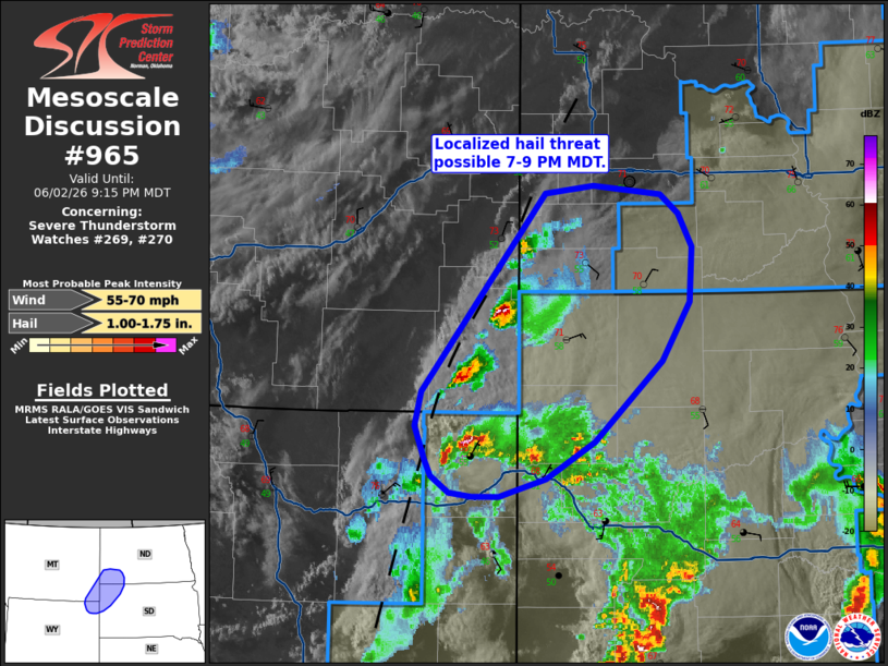 | |
Mesoscale Discussion 0965 NWS Storm Prediction Center Norman OK 0813 PM CDT Tue Jun 02 2026 Areas affected...Far northeast Wyoming into far southeast Montana and the western Dakotas Concerning...Severe Thunderstorm Watch 269...270... Valid 030113Z - 030315Z The severe weather threat for Severe Thunderstorm Watch 269, 270 continues. SUMMARY...Additional T-storm development noted in GOES imagery suggests the threat for large hail may continues across portions of WW 269 and WW 270 for the next couple of hours. DISCUSSION...GOES imagery and lightning data show a recent uptick in convective activity across far northeast WY and southwest MT along a residual surface confluence zone. Low-level ascent is likely being augmented by the approach of a subtle perturbation migrating across north-central WY (per latest low-level water vapor imagery), which may explain the recent uptick in convective activity over the past 45 minutes. The early onset of nocturnal cooling is evident in surface observations across the region and will only be exacerbated heading into the late evening hours. Although some convective overturning has already occurred earlier today, the immediate downstream environment appears to be adequately buoyant to support deep convection based on forecast soundings from recent-high res guidance (which appear to be capturing low-level cooling trends well). Additionally, 35-40 knot mid-level flow sampled by KBIS hints that deep-layer wind shear across the region remains favorable for organized convection. It remains unclear how intense convection will become across far southeast MT and into the Dakotas given the onset of nocturnal cooling within the residual air mass, but some threat for large hail, and perhaps severe wind, appears possible if convection continues to mature. ..Moore.. 06/03/2026 ...Please see www.spc.noaa.gov for graphic product... ATTN...WFO...BIS...UNR...BYZ... LAT...LON 44890519 45150511 46700375 46770321 46690246 46550225 46290210 45860214 45400245 44770319 44470374 44340425 44330456 44370480 44490500 44620508 44890519 MOST PROBABLE PEAK WIND GUST...55-70 MPH MOST PROBABLE PEAK HAIL SIZE...1.00-1.75 IN | |
| Top/All Mesoscale Discussions/Forecast Products/Home | |