|
|
| Mesoscale Discussion 936 | |
| Next MD > | |
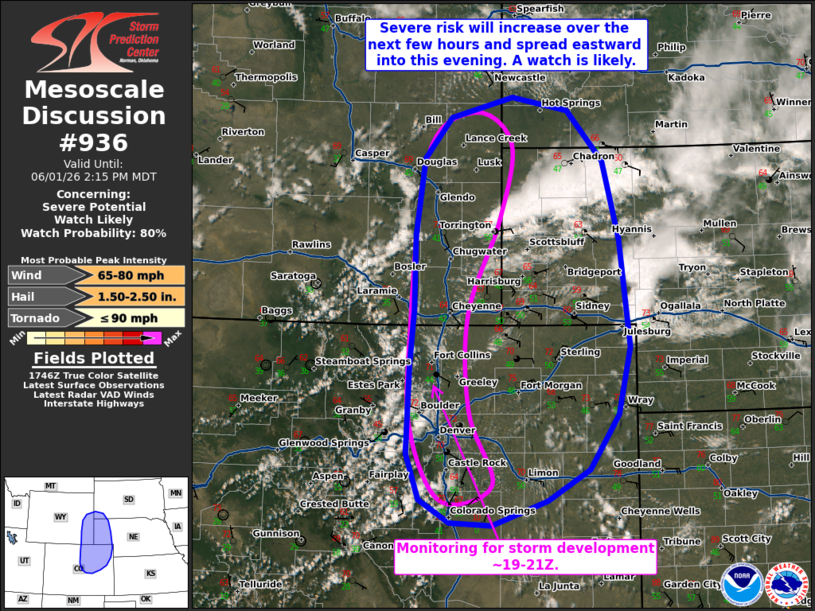 | |
   Mesoscale Discussion 0936
   NWS Storm Prediction Center Norman OK
   1251 PM CDT Mon Jun 01 2026

   Areas affected...Northeast CO...NE Panhandle...southeast WY...far
   southwest SD

   Concerning...Severe potential...Watch likely

   Valid 011751Z - 012015Z

   Probability of Watch Issuance...80 percent

   SUMMARY...Severe storms are initially expected along the higher
   terrain before spreading eastward into this evening. Large to very
   large hail and severe gusts are the main concerns. One or more
   watches are likely this afternoon.

   DISCUSSION...Increasingly agitated boundary-layer cumulus is
   evolving along the higher terrain from CO into WY this afternoon.
   Continued diurnal heating amid terrain circulations should erode
   remaining inhibition and support widely scattered thunderstorm
   development in the 19-21Z time frame. Steepening deep-layer lapse
   rates (per earlier DEN ACARS sounding) and around 40 kt of effective
   shear (characterized by a long/mostly straight mid/upper-level
   hodograph) will favor large to very large hail with initially
   discrete/semi-discrete supercell structures. While uncertain, a
   brief tornado cannot be ruled out where terrain-induced low-level
   vorticity is enhanced in eastern CO.

   With time, this activity will track eastward into the foothills and
   eventually the Plains, where moist upslope flow will promote a
   continued risk of large hail and severe wind gusts. Localized
   upscale growth into eastward-moving clusters will favor an
   increasing risk of severe gusts into this evening. One or more
   watches will be needed this afternoon.

   ..Weinman/Mosier.. 06/01/2026

   ...Please see www.spc.noaa.gov for graphic product...

   ATTN...WFO...LBF...UNR...GLD...PUB...BOU...CYS...

   LAT...LON   38760481 39020525 39540544 40540541 41170535 42000534
               42880521 43330481 43560388 43420306 42840253 41970229
               40750214 39980232 39370275 39020337 38740419 38760481

   MOST PROBABLE PEAK TORNADO INTENSITY...UP TO 90 MPH
   MOST PROBABLE PEAK WIND GUST...65-80 MPH
   MOST PROBABLE PEAK HAIL SIZE...1.50-2.50 IN
| |
| Top/All Mesoscale Discussions/Forecast Products/Home | |