|
|
| Mesoscale Discussion 910 | |
| Next MD > | |
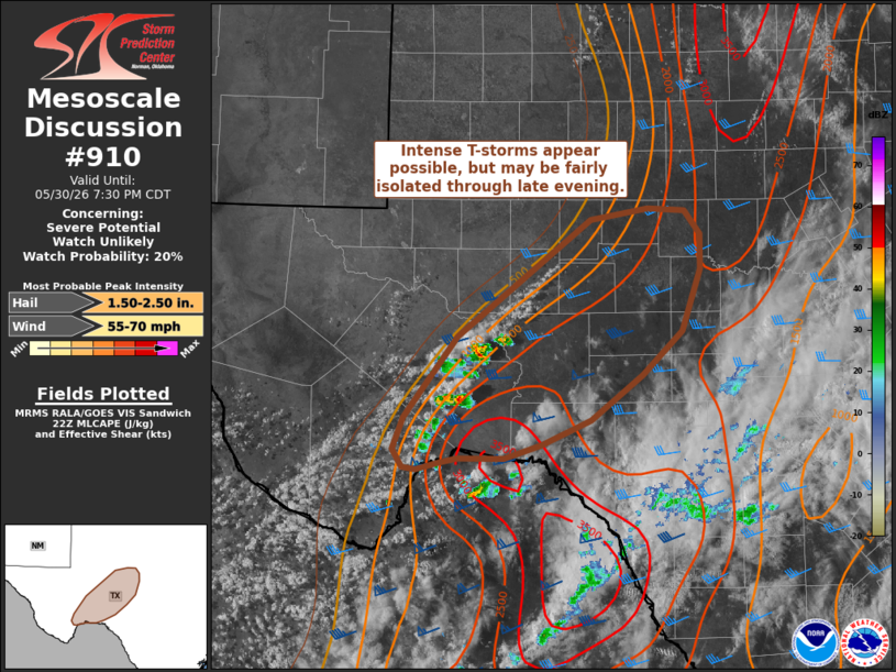 | |
   Mesoscale Discussion 0910
   NWS Storm Prediction Center Norman OK
   0531 PM CDT Sat May 30 2026

   Areas affected...Portions of the Edwards Plateau of southern Texas

   Concerning...Severe potential...Watch unlikely

   Valid 302231Z - 310030Z

   Probability of Watch Issuance...20 percent

   SUMMARY...Thunderstorm development across the Big Bend/Edwards
   Plateau region may be very isolated, but the downstream environment
   may support intense convection through late evening. Watch issuance
   is currently not expected given limited storm coverage.

   DISCUSSION...Convection has been percolating along a dryline across
   the Big Bend/Edwards Plateau over the past couple of hours. Although
   deep initiation has struggled to remain sustained, lightning trends
   within a couple of deeper convective cores east/southeast of Fort
   Stockton, TX have increased over the past 20 minutes, hinting at a
   higher potential for sustained convection. If mature thunderstorms
   can be established, they will quickly migrate into an environment
   very favorable for intense convection (MLCAPE of 2000-3000 J/kg with
   elongated hodographs featuring 45 knots of effective bulk shear).
   Within this environment, splitting supercells appear probable and
   will pose a threat for large to very large hail as well as severe
   gusts. Given weak synoptic-scale forcing for ascent, it remains to
   be seen whether these more recent attempts at sustained convection
   will succeed or whether storm coverage will be more than a storm or
   two. Because of these concerns watch issuance is currently not
   anticipated, but trends will be monitored.

   ..Moore/Guyer.. 05/30/2026

   ...Please see www.spc.noaa.gov for graphic product...

   ATTN...WFO...EWX...SJT...MAF...

   LAT...LON   29680273 29710286 29870297 30150285 30870231 31910093
               32010035 31999996 31779981 31469980 30929999 30520041
               30120094 29910144 29790183 29790230 29750249 29680273

   MOST PROBABLE PEAK WIND GUST...55-70 MPH
   MOST PROBABLE PEAK HAIL SIZE...1.50-2.50 IN
| |
| Top/All Mesoscale Discussions/Forecast Products/Home | |