|
|
| Mesoscale Discussion 882 | |
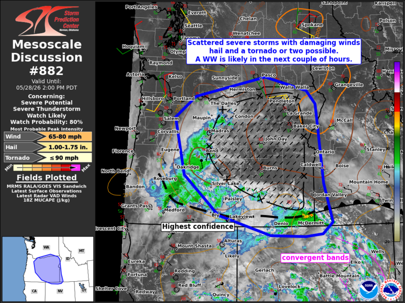 | |
   Mesoscale Discussion 0882
   NWS Storm Prediction Center Norman OK
   0129 PM CDT Thu May 28 2026

   Areas affected...portions the Northwest and northern Great Basin

   Concerning...Severe potential...Severe Thunderstorm Watch likely

   Valid 281829Z - 282100Z

   Probability of Watch Issuance...80 percent

   SUMMARY...Scattered to numerous thunderstorms are likely this
   afternoon and evening over portions of the Pacific Northwest and
   northern Great Basin. Convection should increase in coverage with a
   risk for severe/damaging wind gusts, hail and perhaps a tornado or
   two. A WW is likely, though timing remains uncertain.

   DISCUSSION...As of 1830 UTC, WV imagery showed a deep upper low over
   central CA with several prominent shortwave troughs embedded within
   the broader cyclonic flow. Visible imagery showed a broad area of
   cumuliform clouds in vicinity to the most prominent shortwave
   feature rotating northward across central and northern NV.
   Unseasonably high surface moisture (dewpoints in the 40s and 50s F)
   is in place over OR, WA, and ID. As diurnal heating continues
   beneath cool mid-level temperatures, steepening low and mid-level
   lapse rates will contribute to moderate destabilization and
   thunderstorm development/intensification.

   A very complex convective evolution is expected this afternoon. CAM
   guidance shows several bands of convection gradually deepening over
   northern NV and moving northwestward with the strong shortwave
   trough. Additional storms may develop along local terrain features
   and across the diffuse synoptic boundary across southern OR. 50+ kt
   of east/southerly mid-level flow will overspread the instability,
   contributing to moderate/strong effective shear. Initially more
   cellular storms may organize into supercells or clusters. Most
   guidance shows eventual upscale growth into a more linear structure
   with time.

   Steep lapse rates and the enhanced flow aloft suggest severe wind
   gusts are the most likely hazard. Some hail may also occur, given
   cool mid-level temperatures and the degree of buoyancy. Unusually
   strong low-level shear beneath the easterly jet aloft may also
   support a risk for a tornado or two, especially with any persistent
   supercells.

   The severe risk is expected to increase from midday into this
   evening as the upper trough rotates northward and intersects with
   the more unstable air mass. The highest confidence in a sustained
   severe risk resides east of the Cascades over much of OR currently.
   This will likely necessitate one or more Severe Thunderstorm Watches
   this afternoon/evening. However, confidence in the exact timing
   remains very uncertain.

   ..Lyons/Hart.. 05/28/2026

   ...Please see www.spc.noaa.gov for graphic product...

   ATTN...WFO...BOI...LKN...PDT...REV...MFR...PQR...

   LAT...LON   42622108 43462210 45102252 45702170 46271890 45881725
               45501690 45021683 43221664 42101631 41761670 41691738
               41741872 42312075 42622108

   MOST PROBABLE PEAK TORNADO INTENSITY...UP TO 90 MPH
   MOST PROBABLE PEAK WIND GUST...65-80 MPH
   MOST PROBABLE PEAK HAIL SIZE...1.00-1.75 IN
| |
| Top/All Mesoscale Discussions/Forecast Products/Home | |