|
|
| Mesoscale Discussion 871 | |
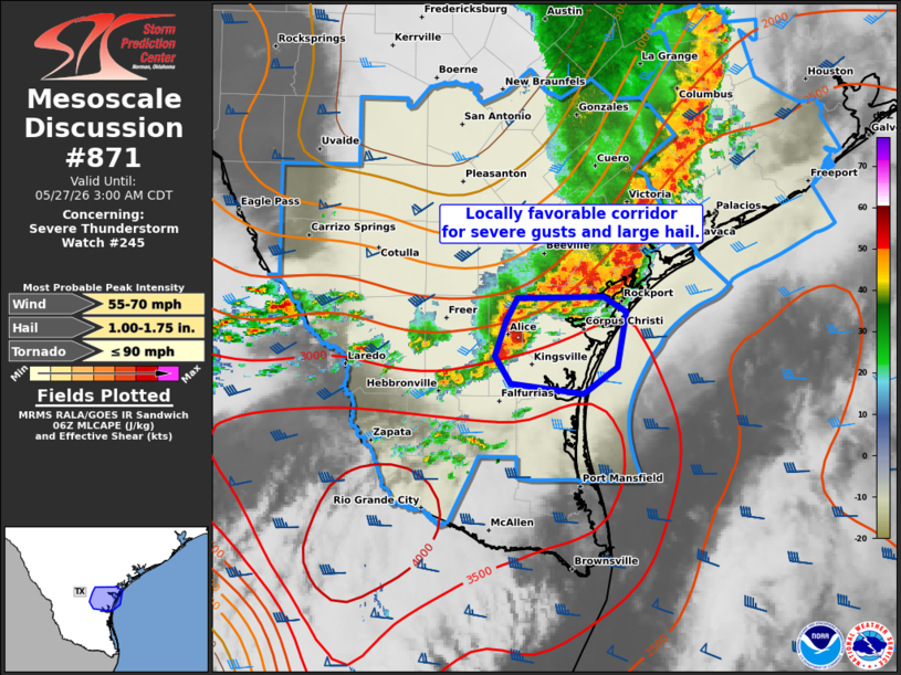 | |
Mesoscale Discussion 0871 NWS Storm Prediction Center Norman OK 0123 AM CDT Wed May 27 2026 Areas affected...Parts of the Lower/Middle Texas Coast and vicinity Concerning...Severe Thunderstorm Watch 245... Valid 270623Z - 270800Z The severe weather threat for Severe Thunderstorm Watch 245 continues. SUMMARY...A locally favorable corridor for severe wind gusts and large hail is evident over parts of the Lower/Middle TX Coast and vicinity during the next hour or so. DISCUSSION...Along the southern end of an eastward-moving MCS approaching the Middle TX Coast, a somewhat separated cluster of thunderstorms is tracking eastward at around 40 kt toward Corpus Christi and vicinity. Around 40 kt of deep-layer shear oriented perpendicular to the gust front of this upscale-growing cluster and moist/moderately unstable surface-based inflow (sampled by the 00Z CRP sounding) will favor a corridor of severe wind gusts (around 60-70 mph) and possibly large hail as it moves toward the coast over the next hour or so. ..Weinman.. 05/27/2026 ...Please see www.spc.noaa.gov for graphic product... ATTN...WFO...CRP... LAT...LON 27279738 27359804 27579817 27859808 28039798 28049721 27929700 27489708 27279738 MOST PROBABLE PEAK TORNADO INTENSITY...UP TO 90 MPH MOST PROBABLE PEAK WIND GUST...55-70 MPH MOST PROBABLE PEAK HAIL SIZE...1.00-1.75 IN | |
| Top/All Mesoscale Discussions/Forecast Products/Home | |