

|
|
| Mesoscale Discussion 845 | |
 | |
   Mesoscale Discussion 0845
   NWS Storm Prediction Center Norman OK
   1246 AM CDT Sun May 24 2026

   Areas affected...Parts of western North TX and far southwestern OK

   Concerning...Severe potential...Watch unlikely

   Valid 240546Z - 240715Z

   Probability of Watch Issuance...20 percent

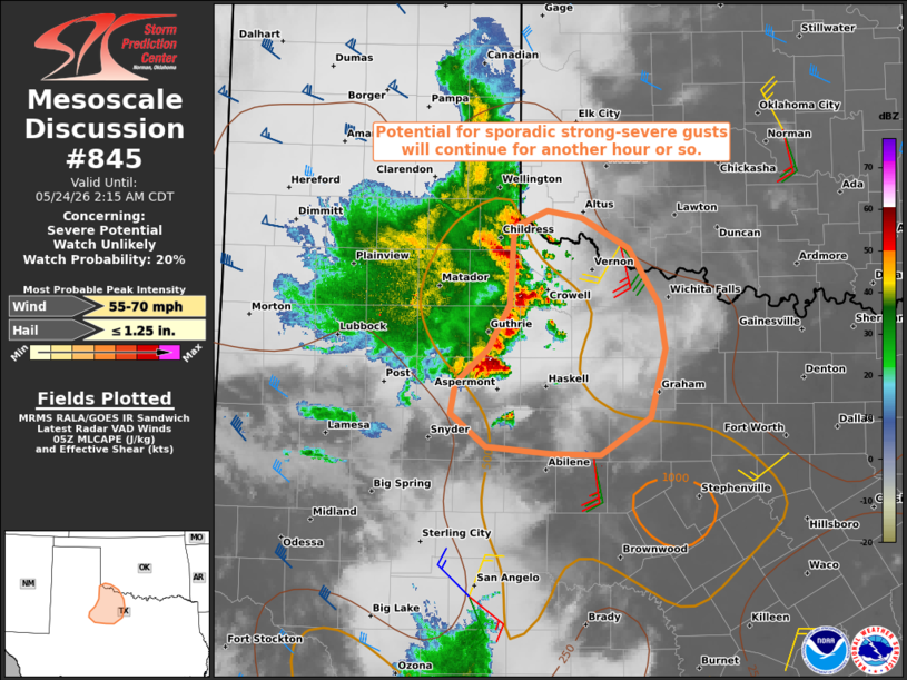
   SUMMARY...Potential for sporadic strong-severe gusts will continue
   for another hour or so.

   DISCUSSION...A cluster of thunderstorms with a recent history of
   producing measured gusts of 60-75 mph is tracking east-southeastward
   across western North TX and far southwestern OK. While large-scale
   forcing for ascent is weak and the low-level jet is not particularly
   strong, recent radar data from LBB and FDR indicate a trailing
   stratiform region and signs of an established (albeit modest)
   rear-inflow jet. Related cold pool dynamics should continue to
   support new updrafts along the leading gust front as it tracks
   east-southeastward through a corridor of weakly unstable air, and
   sporadic strong-severe gusts will remain possible before this
   cluster weakens over the next couple hours.

   ..Weinman/Smith.. 05/24/2026

   ...Please see www.spc.noaa.gov for graphic product...

   ATTN...WFO...FWD...OUN...SJT...LUB...MAF...

   LAT...LON   33180064 33470031 33840010 34510005 34649971 34589936
               34329889 33859858 33469851 32889866 32579917 32589967
               32630033 32910069 33180064

   MOST PROBABLE PEAK WIND GUST...55-70 MPH
   MOST PROBABLE PEAK HAIL SIZE...UP TO 1.25 IN
| |
| Top/All Mesoscale Discussions/Forecast Products/Home | |