

|
|
| Mesoscale Discussion 843 | |
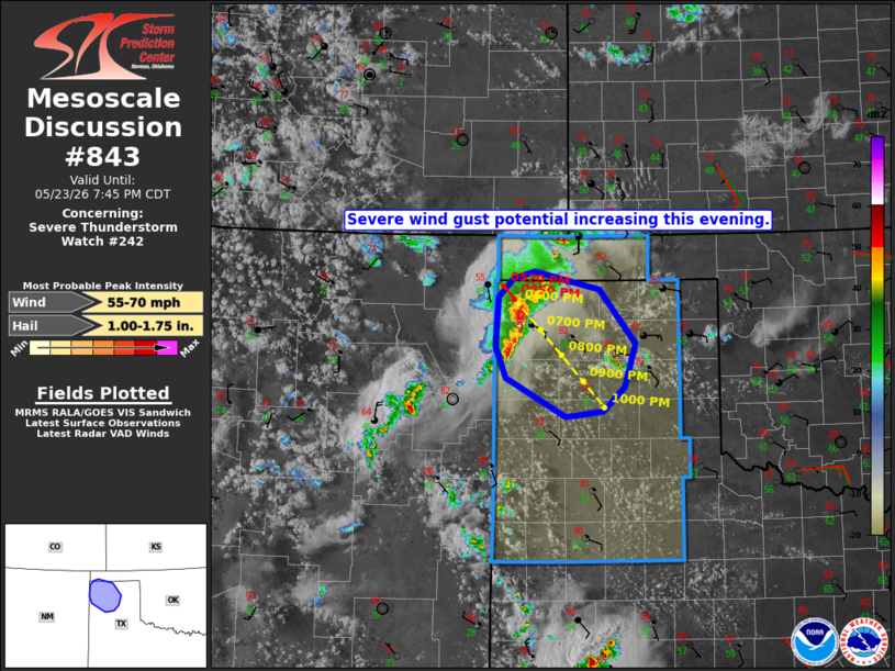 | |
Mesoscale Discussion 0843 NWS Storm Prediction Center Norman OK 0616 PM CDT Sat May 23 2026 Areas affected...The Texas Panhandle Concerning...Severe Thunderstorm Watch 242... Valid 232316Z - 240045Z The severe weather threat for Severe Thunderstorm Watch 242 continues. SUMMARY...The potential for severe wind gusts will increase through 02z (9 PM CDT) from the northwest into central Texas Panhandle. Isolated occurrences of large hail are also possible. DISCUSSION...Over the past hour, individual thunderstorms have consolidated in to a line, which extends from south-central Cimarron County in the western OK Panhandle southwest through western parts of Dallam and Hartley Counties in the northwest Tx Panhandle as of 2310 UTC. Recent KAMA base velocity data indicate multiple channels of stronger winds embedded within the line, suggestive of a gradually organizing cold pool. The downstream air mass across the TX Panhandle is modestly moist with steep low/mid-level lapse rates largely contributing to MLCAPE up to 1500 J/kg, per objective analysis. The current KAMA VWP is sampling southeasterly winds within the lowest 2-3-km AGL, which are forecast to strengthen in the 01-03z time frame, effectively enhancing storm-relative inflow into the evolving convective system. That coupled with around 30-35 kt of effective bulk shear, and the steep lapse rates may support the southeastward acceleration of the ongoing thunderstorm line into the central Panhandle by 02z (9 PM CDT) or earlier, with an attendant risk for severe wind gusts of 60-70 mph and isolated occurrences of large hail. ..Mead.. 05/23/2026 ...Please see www.spc.noaa.gov for graphic product... ATTN...WFO...AMA... LAT...LON 35770303 36310298 36520279 36600249 36390162 35790113 35320128 35050156 34990207 35420289 35770303 MOST PROBABLE PEAK WIND GUST...55-70 MPH MOST PROBABLE PEAK HAIL SIZE...1.00-1.75 IN | |
| Top/All Mesoscale Discussions/Forecast Products/Home | |