

|
|
| Mesoscale Discussion 838 | |
| Next MD > | |
 | |
   Mesoscale Discussion 0838
   NWS Storm Prediction Center Norman OK
   0124 PM CDT Sat May 23 2026

   Areas affected...portions of northeastern Colorado...western/central
   nebraska and northwest Kansas

   Concerning...Severe potential...Watch unlikely

   Valid 231824Z - 232130Z

   Probability of Watch Issuance...20 percent

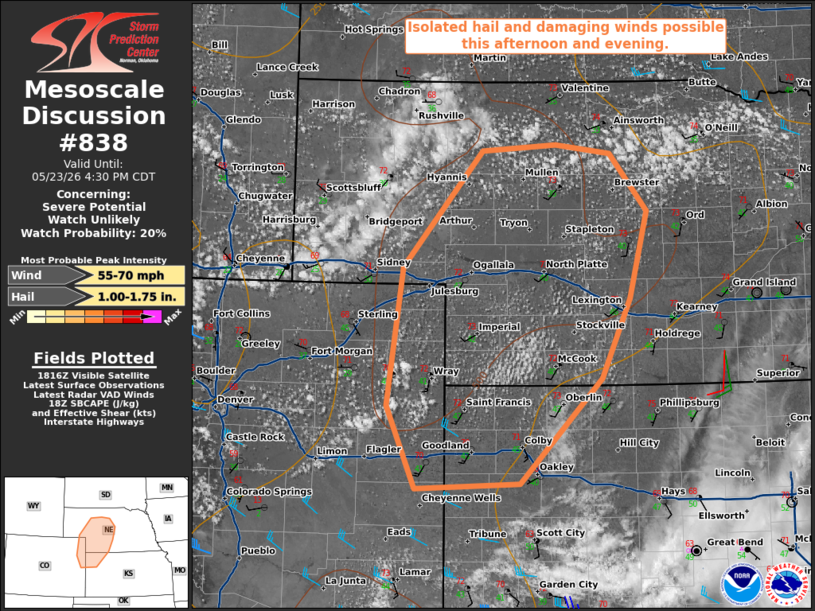
   SUMMARY...Thunderstorm development is expected this afternoon across
   the central High Plains. A few stronger storms could emerge with a
   risk for isolated hail and damaging winds. A watch is unlikely.

   DISCUSSION...As of 1820 UTC, visible imagery showed initial ACCAS
   and boundary layer cumulus over parts of NE/CO was beginning to
   deepen with diurnal warming. This heating, amid modest (40s F)
   surface dewpoints is support weak destabilization, which should
   continue through the afternoon. Aided by weak ascent from a broad
   upper trough over the High Plains, scattered thunderstorms are
   expected to develop and spread eastward into this evening.

   While initially buoyancy (SBCAPE ~ 500 J/kg) and vertical shear will
   be on the weaker side, 20-30 kt of effective shear could support a
   few organized multi cell clusters. Steep lapse rates in the low and
   mid-level should support a risk for some hail and damaging gusts
   with the stronger storms. CAM solutions show some clustering as
   convection gradually spreads eastward with a slight increase in
   deep-layer shear late this afternoon into the early evening. While
   an isolated severe risk is possible, the weaker buoyancy and
   initially more limited vertical shear should keep the threat
   isolated. Thus a WW is unlikely at this time.

   ..Lyons/Guyer.. 05/23/2026

   ...Please see www.spc.noaa.gov for graphic product...

   ATTN...WFO...GID...LBF...GLD...BOU...CYS...

   LAT...LON   40060001 39020108 38970243 39800279 41170259 42310156
               42380061 42289989 41729941 40869964 40060001

   MOST PROBABLE PEAK WIND GUST...55-70 MPH
   MOST PROBABLE PEAK HAIL SIZE...1.00-1.75 IN
| |
| Top/All Mesoscale Discussions/Forecast Products/Home | |