

|
|
| Mesoscale Discussion 785 | |
 | |
   Mesoscale Discussion 0785
   NWS Storm Prediction Center Norman OK
   0954 AM CDT Tue May 19 2026

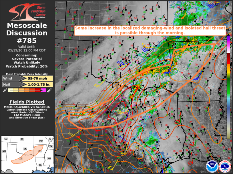
   Areas affected...Parts of north TX...southeast OK...AR

   Concerning...Severe potential...Watch unlikely

   Valid 191454Z - 191700Z

   Probability of Watch Issuance...20 percent

   SUMMARY...Some increase in the localized damaging-wind and isolated
   hail threat is possible through the morning.

   DISCUSSION...Extensive convection is ongoing this morning from north
   TX into southeast OK and northern AR, generally along and to the
   cool side of a southeastward-moving cold front. Very rich low-level
   moisture and strong buoyancy are in place south of the front, with a
   mean mixing ratio of 17.6 g/kg observed on the 12Z FWD sounding,
   beneath steep midlevel lapse rates. Filtered heating may allow for
   gradual intensification of ongoing convection through the morning,
   as storms continue to spread southeastward in conjunction with the
   front. Additional development is possible within a prefrontal
   confluence zone across north TX.

   While favorable thermodynamics will support potential for robust
   updrafts through the day, storm organization will likely be hampered
   by generally weak deep-layer flow/shear. A moderate low-level jet
   noted in regional VWPs is expected to shift northeastward and weaken
   through the day. Modest mid/upper-level flow may weaken further from
   northeast TX into AR, along the northern periphery of an MCV
   tracking well to the south near the upper TX coast.

   Given the generally weak flow, damaging-wind potential will be
   driven by localized downbursts and any larger-scale cold pools that
   can develop and spread southeastward. This potential will be
   maximized in areas where the strongest preconvective heating occurs.
   Isolated hail also cannot be ruled out, given the favorable
   buoyancy. Watch issuance is unlikely through the morning, unless a
   notable uptick in storm intensity and organization occurs.

   ..Dean/Hart.. 05/19/2026

   ...Please see www.spc.noaa.gov for graphic product...

   ATTN...WFO...LZK...SHV...TSA...FWD...OUN...SJT...MAF...

   LAT...LON   31460069 31840138 32300135 32330067 32659984 33129861
               34129761 34919617 35169447 35999418 36229290 36289130
               35469167 34359298 32799535 31629839 31400028 31460069

   MOST PROBABLE PEAK WIND GUST...55-70 MPH
   MOST PROBABLE PEAK HAIL SIZE...1.00-1.75 IN
| |
| Top/All Mesoscale Discussions/Forecast Products/Home | |