|
|
| Mesoscale Discussion 781 | |
| Next MD > | |
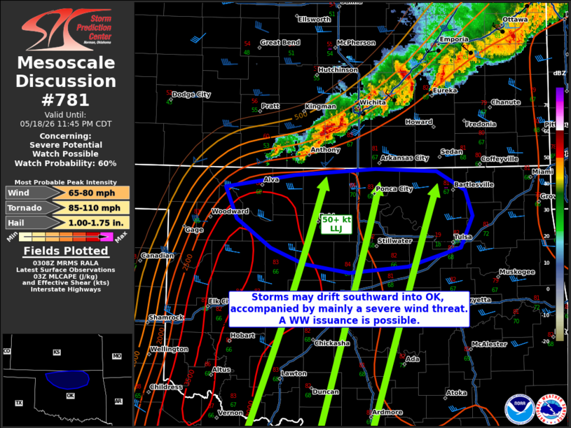 | |
   Mesoscale Discussion 0781
   NWS Storm Prediction Center Norman OK
   1010 PM CDT Mon May 18 2026

   Areas affected...portions of northern Oklahoma

   Concerning...Severe potential...Watch possible

   Valid 190310Z - 190445Z

   Probability of Watch Issuance...60 percent

   SUMMARY...The severe threat may increase over northern OK over the
   next few hours as storms back-build southwestward along a southward
   drifting cold front. Severe gusts are the main threat, though an
   instance or two of hail or a tornado are possible. Convective trends
   are being monitored for the need of a WW issuance.

   DISCUSSION...Robust multicellular convection, with a history of
   measured severe gusts, has been steadily back-building
   west-southwestward along and immediately behind a southward sagging
   cold front. Despite weak upper support, strong low-level convergence
   has been supporting persistent convective development, especially
   given a 50 kt southerly low-level jet bisecting the cold front
   nearly perpendicularly. Ahead of the front, upper 60s F surface
   dewpoints beneath 8-9 C/km mid-level lapse rates are yielding 3000+
   J/kg MLCAPE per the 00Z OUN/LMN soundings and 02Z mesoanalysis.
   These same data sources also depict sizeable low-level hodographs
   with 300 m2/s2 effective SRH and 40+ kts of effective bulk shear. As
   such, the ambient environment clearly supports severe potential.

   The primary uncertainty is how far southwest convection will
   initiate along the southward-sagging front, and the timing for
   storms to propagate into OK. The current thinking is that storms
   capable of severe gusts will eventually propagate southward into
   north-central and northeast OK. An instance or two of severe hail
   could accompany the stronger storm cores, and a tornado cannot be
   ruled out if a robust updraft can outpace the cold front. Convective
   trends will continue to be monitored for convective propagation into
   OK.

   ..Squitieri/Mosier.. 05/19/2026

   ...Please see www.spc.noaa.gov for graphic product...

   ATTN...WFO...TSA...OUN...

   LAT...LON   36779919 36929821 36999709 36969623 36739582 36449572
               36099589 35879664 35809745 35909809 36089856 36429904
               36779919

   MOST PROBABLE PEAK TORNADO INTENSITY...85-110 MPH
   MOST PROBABLE PEAK WIND GUST...65-80 MPH
   MOST PROBABLE PEAK HAIL SIZE...1.00-1.75 IN
| |
| Top/All Mesoscale Discussions/Forecast Products/Home | |