|
|
| Mesoscale Discussion 749 | |
| Next MD > | |
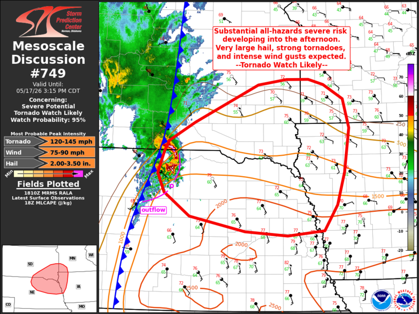 | |
   Mesoscale Discussion 0749
   NWS Storm Prediction Center Norman OK
   0111 PM CDT Sun May 17 2026

   Areas affected...southeast SD...northeast NE...northwest IA...and
   southwest MN

   Concerning...Severe potential...Tornado Watch likely

   Valid 171811Z - 172015Z

   Probability of Watch Issuance...95 percent

   SUMMARY...Severe potential will increase over the next couple of
   hours across southeast South Dakota and northeast Nebraska into
   adjacent portions of Minnesota and Iowa. A substantial all-hazards
   severe risk is expected by mid-afternoon into this evening. Very
   large hail to 3.5 inch diameter, strong tornadoes, and intense wind
   gusts to 90 mph appear likely. A tornado watch will likely be issued
   by 19z to 20z.

   DISCUSSION...A cluster of elevated convection is ongoing across
   north-central NE ahead of the surface cold front. The downstream
   airmass is quickly destabilizing as rich boundary-layer moisture
   (mid to upper 60s F dewpoints) spreads north and west amid strong
   heating. Immediately downstream from the ongoing thunderstorm
   cluster, latest mesoanalysis indicates weakening midlevel capping.
   This is supported by increasing cumulus from Brown to Knox and
   Antelope Counties in NE in the vicinity of a quasi-stationary
   boundary/warm front. Increasing midlevel southwesterly flow is
   evident in the past couple of hours on region VWP. This trend should
   continue, with additional strengthening of low-level flow in
   response to surface pressure falls. Vertically veering wind profiles
   with 40+ kt effective shear magnitudes within moderate to strong
   instability (by mid/late afternoon) will support robust supercell
   development within the warm sector on the nose of the midlevel dry
   slot across the northeast NE vicinity. Discrete supercells will pose
   a risk for very large hail, strong tornadoes, and damaging wind
   gusts.

   Additional linear convection is expected along the cold front,
   particularly across SD into southern MN. Given favorable low-level
   shear, line-embedded cells/mesovortices will pose a tornado risk
   even in linear convection. As linear convection organizes and a
   low-level jet increases toward late afternoon into the evening, a
   substantial damaging wind risk may evolve.

   ..Leitman/Mosier.. 05/17/2026

   ...Please see www.spc.noaa.gov for graphic product...

   ATTN...WFO...DMX...FSD...OAX...GID...LBF...UNR...

   LAT...LON   41509588 41419680 41489786 41779924 42209988 42570005
               42989990 43169978 43529913 44229752 44329681 44329625
               44229587 43959537 43419522 42589536 41979555 41509588

   MOST PROBABLE PEAK TORNADO INTENSITY...120-145 MPH
   MOST PROBABLE PEAK WIND GUST...75-90 MPH
   MOST PROBABLE PEAK HAIL SIZE...2.00-3.50 IN
| |
| Top/All Mesoscale Discussions/Forecast Products/Home | |