

|
|
| Mesoscale Discussion 716 | |
| Next MD > | |
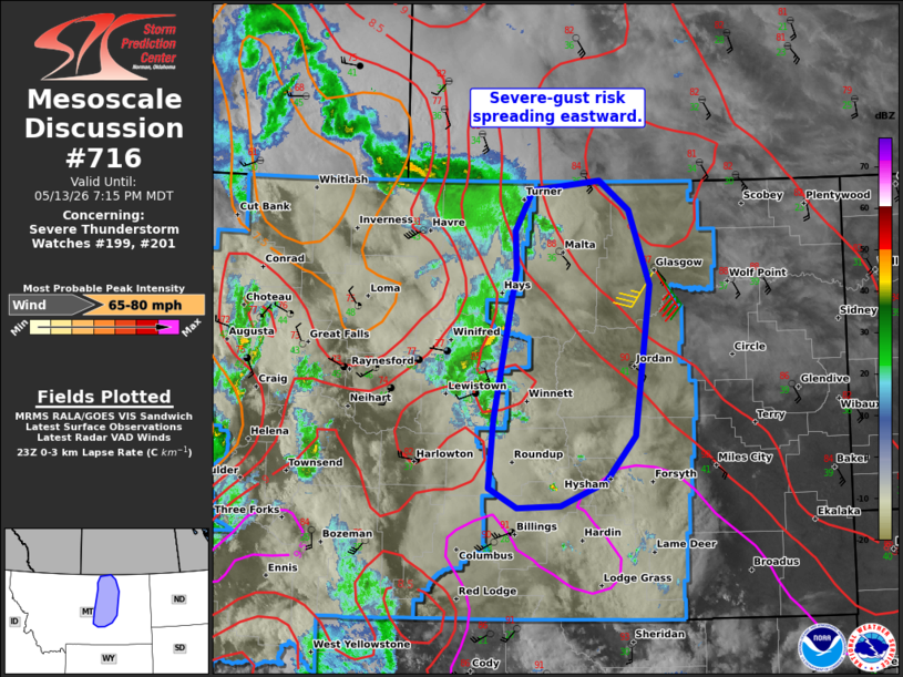 | |
Mesoscale Discussion 0716 NWS Storm Prediction Center Norman OK 0647 PM CDT Wed May 13 2026 Areas affected...Parts of eastern Montana Concerning...Severe Thunderstorm Watch 199...201... Valid 132347Z - 140115Z The severe weather threat for Severe Thunderstorm Watch 199, 201 continues. SUMMARY...The risk of severe gusts (some upwards of 75 mph) will continue spreading eastward into eastern Montana -- within WW201. DISCUSSION...High-based thunderstorms moving eastward into eastern MT have evolved into a loosely organized squall line along a north/south-oriented surface trough/confluence zone. This band of storms will continue spreading eastward in tandem with the leading edge of midlevel height falls accompanying a robust midlevel trough. Around 40 kt of midlevel west-southwesterly flow oriented perpendicular to the leading gust front and a hot/dry pre-convective boundary layer will favor a continued risk of severe wind gusts (some possibly up to 75 mph) with eastward extent (within WW201). ..Weinman.. 05/13/2026 ...Please see www.spc.noaa.gov for graphic product... ATTN...WFO...BYZ...GGW...TFX... LAT...LON 46200885 46820879 48190849 48550850 48910827 49010736 48730697 48060669 46670688 46260728 46040789 46020846 46200885 MOST PROBABLE PEAK WIND GUST...65-80 MPH | |
| Top/All Mesoscale Discussions/Forecast Products/Home | |