

|
|
| Mesoscale Discussion 711 | |
| Next MD > | |
 | |
   Mesoscale Discussion 0711
   NWS Storm Prediction Center Norman OK
   1141 AM CDT Wed May 13 2026

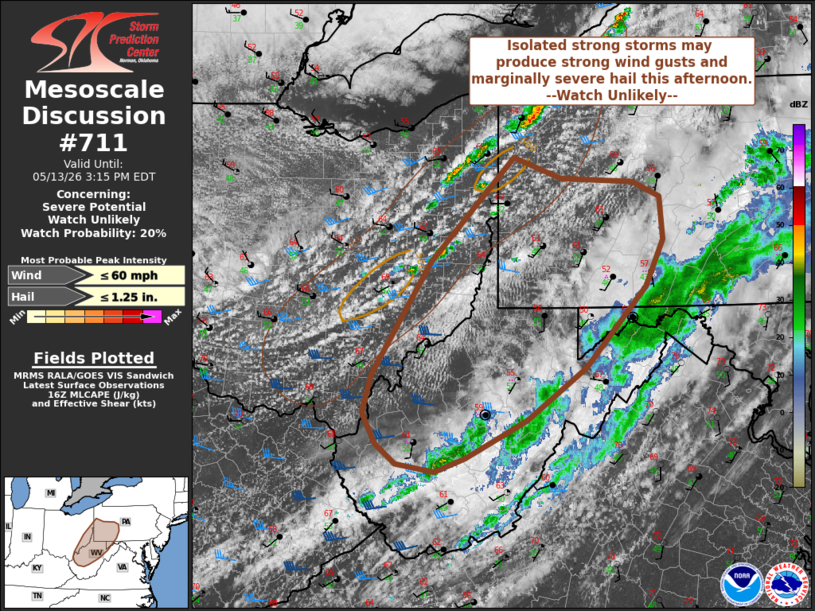
   Areas affected...southwest PA...southeast OH...and parts of WV

   Concerning...Severe potential...Watch unlikely

   Valid 131641Z - 131915Z

   Probability of Watch Issuance...20 percent

   SUMMARY...Isolated strong wind gusts and hail are possible this
   afternoon. A severe thunderstorm watch is unlikely at this time.

   DISCUSSION...Thunderstorms are developing near and just ahead of a
   surface cold front from far western NY into eastern OH. Pockets of
   stronger heating have occurred ahead of this activity across
   southwest PA into OH and parts of WV where some clearing has
   occurred in the wake of early day cloudiness and showers. This has
   allowed temperatures to warm into the low/mid 60s amid 50s
   dewpoints. While boundary layer moisture will remain modest, cold
   temperatures aloft will support steepened midlevel lapse rates. As a
   result, modest destabilization is underway within a narrow corridor
   ahead of the front. Instability is likely to remain modest, with
   generally less than 750 J/kg MLCAPE expected by peak heating. While
   upper level flow will be moderate, low-level flow is expected to be
   somewhat less compared to further north closer to the surface low.
   In fact, forecast guidance indicates 850 mb flow will weaken through
   the day. Nevertheless, effective shear magnitudes will be sufficient
   for some organized storm structures. However, limited instability
   and modest boundary layer moisture will likely preclude more
   substantial severe potential. Locally strong wind gusts and
   marginally severe hail will be possible with the strongest cells,
   but overall severe is expected to remain sparse, negating watch
   issuance at this time.

   ..Leitman/Mosier.. 05/13/2026

   ...Please see www.spc.noaa.gov for graphic product...

   ATTN...WFO...CTP...LWX...PBZ...RLX...CLE...

   LAT...LON   41228031 41027968 40987875 40837840 40407835 39927858
               39127936 38598013 38218092 38078132 38158182 38348209
               38658226 39038215 40188139 41228031

   MOST PROBABLE PEAK WIND GUST...UP TO 60 MPH
   MOST PROBABLE PEAK HAIL SIZE...UP TO 1.25 IN
| |
| Top/All Mesoscale Discussions/Forecast Products/Home | |