

|
|
| Mesoscale Discussion 684 | |
| Next MD > | |
 | |
   Mesoscale Discussion 0684
   NWS Storm Prediction Center Norman OK
   0110 PM CDT Sat May 09 2026

   Areas affected...portions of the central High Plains

   Concerning...Severe potential...Watch unlikely

   Valid 091810Z - 092045Z

   Probability of Watch Issuance...20 percent

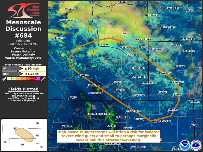
   SUMMARY...High-based thunderstorms will bring a risk for isolated
   severe wind gusts and small to perhaps marginally severe hail this
   afternoon from southeastern Wyoming into the Nebraska Panhandle and
   northeastern Colorado.

   DISCUSSION...Latest GOES water vapor imagery depicts a mid-level
   shortwave trough embedded within broad northwesterly flow moving
   southeastward from southern Montana into northwestern Wyoming.
   While low-level moisture remains very limited (dewpoints in the 30s
   F), cooling temperatures aloft downstream of this shortwave and
   continued insolation are yielding steepening low- and mid-level
   lapse rates per latest mesoanalysis. Model forecast soundings
   suggest that this will be sufficient for the development of weak
   buoyancy (250-500+ J/kg MLCAPE) by early-to-mid afternoon.
   Expectation is for ongoing, high-based convection across northern
   Wyoming to progress southeastward, with additional development
   likely across the high terrain areas of central/southeastern Wyoming
   over the next couple of hours.

   Despite the aforementioned limited low-level moisture, steep
   low-level lapse rates and dry, well-mixed boundary layer profiles
   will support the potential for isolated severe wind gusts. 30-40 kts
   of effective bulk shear and steep mid-level lapse rates may also
   promote some risk for small to perhaps marginally severe hail with
   any stronger updrafts. With time, convection will spread
   southeastward into the Nebraska Panhandle and northeastern Colorado,
   with some potential for upscale growth into linear segments should
   cold pools coalesce. Given the forecast limited coverage/magnitude
   of the severe threat, watch issuance is unlikely at this time.

   ..Chalmers/Gleason.. 05/09/2026

   ...Please see www.spc.noaa.gov for graphic product...

   ATTN...WFO...BOU...CYS...RIW...

   LAT...LON   41680678 42020741 42170765 42450766 42810725 43020649
               43130584 43030532 42640451 41910321 41510269 40970269
               40450309 40310397 40880518 41680678

   MOST PROBABLE PEAK WIND GUST...UP TO 60 MPH
   MOST PROBABLE PEAK HAIL SIZE...UP TO 1.25 IN
| |
| Top/All Mesoscale Discussions/Forecast Products/Home | |