|
|
| Mesoscale Discussion 680 | |
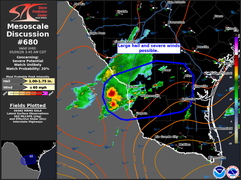 | |
   Mesoscale Discussion 0680
   NWS Storm Prediction Center Norman OK
   0150 AM CDT Sat May 09 2026

   Areas affected...Parts of South/Deep South Texas

   Concerning...Severe potential...Watch unlikely

   Valid 090650Z - 090845Z

   Probability of Watch Issuance...20 percent

   SUMMARY...Large hail and severe wind gusts are possible with
   strong/severe convection moving into the lower Rio Grand Valley
   region. Limited coverage of severe storms is expected to preclude
   watch issuance.

   DISCUSSION...Moist upslope flow into the higher terrain in Mexico
   has promoted storm development earlier this evening. This activity
   is approaching the lower Rio Grande Valley. Given the forcing from
   the shortwave trough moving into South Texas and the minimal CIN on
   account of mid/upper 70s F dewpoints, this activity will likely
   impact portions of South/Deep South Texas. Steep mid-level lapse
   rates and strong effective shear indicate that large hail will be
   possible. Severe winds may also occur, particularly if any upscale
   growth can occur. Radar trends have indicated increasing weak
   thunderstorms over the last hour. Additional development appears
   possible, but severe storm coverage is still currently expected to
   remain low.

   ..Wendt/Hart.. 05/09/2026

   ...Please see www.spc.noaa.gov for graphic product...

   ATTN...WFO...CRP...BRO...

   LAT...LON   27089796 26989812 26909863 26799950 26819965 27019998
               27300012 27610006 27799987 28149876 28079807 27789782
               27219787 27089796

   MOST PROBABLE PEAK WIND GUST...UP TO 60 MPH
   MOST PROBABLE PEAK HAIL SIZE...1.00-1.75 IN
| |
| Top/All Mesoscale Discussions/Forecast Products/Home | |