

|
|
| Mesoscale Discussion 657 | |
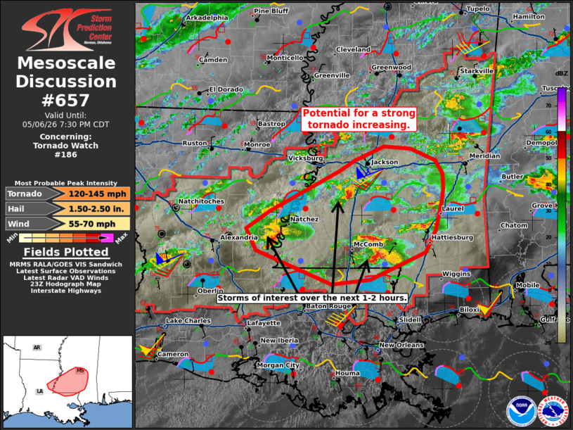 | |
Mesoscale Discussion 0657 NWS Storm Prediction Center Norman OK 0607 PM CDT Wed May 06 2026 Areas affected...southern Mississippi Concerning...Tornado Watch 186... Valid 062307Z - 070030Z The severe weather threat for Tornado Watch 186 continues. SUMMARY...Supercells showing signs of intensification and increasing tornado potential. DISCUSSION...Supercells crossing the LA/MS border and across southern MS have shown an uptick in intensity over the last 30 minutes. VAD profiles from HDC (Hammond,LA) show increasing the 850-700 mb flow beginning to be analyzed just south of the MS border. This increase in the low to mid-level flow will aid in increasing low level shear and thusly an increase in the tornado threat this evening. The cell moving into Walthall County MS has had a tornado reported with it over the last 30 minutes. This cell will continue into a favorable thermodynamic environment across southern MS, where moderate to strong MLCAPE overlaps strong deep layer shear around 50-65 kts. This shows signs of cycling and strengthening. This will continue to pose a risk for tornadoes including potential for a strong tornado. Two other supercells across Concordia County LA and across Copiah County in MS are also become better organized in the low-levels. These are also moving within a very favorable thermodynamic environment and may also pose a risk for tornadoes over the next few hours. ..Thornton.. 05/06/2026 ...Please see www.spc.noaa.gov for graphic product... ATTN...WFO...JAN...LIX...LCH...SHV... LAT...LON 31509204 31729168 32239065 32379041 32558996 32528956 32388919 32208908 32018908 31838910 31488919 31208934 30849017 30799075 31219188 31509204 MOST PROBABLE PEAK TORNADO INTENSITY...120-145 MPH MOST PROBABLE PEAK WIND GUST...55-70 MPH MOST PROBABLE PEAK HAIL SIZE...1.50-2.50 IN | |
| Top/All Mesoscale Discussions/Forecast Products/Home | |